

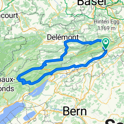
Jurasüdfuss up'n'down
A cycling route starting in Oensingen, Canton of Solothurn, Switzerland.
Overview
About this route
Challenging trail ride at the foot of the Jura Mountains (approx. 52km/2,000m elevation)
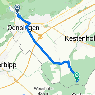
Starting point: Oensingen train station, destination: Olten train station
Uphill on forest and paved roads (occasionally singletrack); downhill on the best trails between Oensingen and Olten (mostly S1 and S2, occasionally S3)
- -:--
- Duration
- 51.3 km
- Distance
- 1,803 m
- Ascent
- 1,879 m
- Descent
- ---
- Avg. speed
- ---
- Max. altitude
Continue with Bikemap
Use, edit, or download this cycling route
You would like to ride Jurasüdfuss up'n'down or customize it for your own trip? Here is what you can do with this Bikemap route:
Free features
- Save this route as favorite or in collections
- Copy & plan your own version of this route
- Sync your route with Garmin or Wahoo
Premium features
Free trial for 3 days, or one-time payment. More about Bikemap Premium.
- Navigate this route on iOS & Android
- Export a GPX / KML file of this route
- Create your custom printout (try it for free)
- Download this route for offline navigation
Discover more Premium features.
Get Bikemap PremiumFrom our community
Other popular routes starting in Oensingen
 Schelten und Chasseral
- Distance
- 163.8 km
- Ascent
- 1,999 m
- Descent
- 2,000 m
- Location
- Oensingen, Canton of Solothurn, Switzerland
 Sur la Scheulte
- Distance
- 44.9 km
- Ascent
- 1,711 m
- Descent
- 883 m
- Location
- Oensingen, Canton of Solothurn, Switzerland
 Jurasüdfuss up'n'down
- Distance
- 51.3 km
- Ascent
- 1,803 m
- Descent
- 1,879 m
- Location
- Oensingen, Canton of Solothurn, Switzerland
 Gigathlon 2012 - Rennvelostrecke Samstag
- Distance
- 101.4 km
- Ascent
- 1,501 m
- Descent
- 1,588 m
- Location
- Oensingen, Canton of Solothurn, Switzerland
 Von Oensingen bis Kestenholz
- Distance
- 6.6 km
- Ascent
- 60 m
- Descent
- 60 m
- Location
- Oensingen, Canton of Solothurn, Switzerland
 Tag1 Oensingen-Schluchsee
- Distance
- 111.2 km
- Ascent
- 879 m
- Descent
- 340 m
- Location
- Oensingen, Canton of Solothurn, Switzerland
 Roggen
- Distance
- 39.9 km
- Ascent
- 1,193 m
- Descent
- 1,271 m
- Location
- Oensingen, Canton of Solothurn, Switzerland
 Oensingen Allerheiligenberg
- Distance
- 37.6 km
- Ascent
- 817 m
- Descent
- 814 m
- Location
- Oensingen, Canton of Solothurn, Switzerland
Open it in the app