

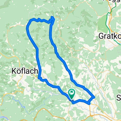
Hirschegg Trail
A cycling route starting in Ligist, Styria, Austria.
Overview
About this route
just an idea - nur ne Idee! = nicht getestet
- -:--
- Duration
- 42.6 km
- Distance
- 1,243 m
- Ascent
- 1,095 m
- Descent
- ---
- Avg. speed
- ---
- Max. altitude
Continue with Bikemap
Use, edit, or download this cycling route
You would like to ride Hirschegg Trail or customize it for your own trip? Here is what you can do with this Bikemap route:
Free features
- Save this route as favorite or in collections
- Copy & plan your own version of this route
- Sync your route with Garmin or Wahoo
Premium features
Free trial for 3 days, or one-time payment. More about Bikemap Premium.
- Navigate this route on iOS & Android
- Export a GPX / KML file of this route
- Create your custom printout (try it for free)
- Download this route for offline navigation
Discover more Premium features.
Get Bikemap PremiumFrom our community
Other popular routes starting in Ligist
 Schilcher Radtour 2023
- Distance
- 31.2 km
- Ascent
- 964 m
- Descent
- 963 m
- Location
- Ligist, Styria, Austria
 2015 Tag 1
- Distance
- 140.8 km
- Ascent
- 1,714 m
- Descent
- 1,528 m
- Location
- Ligist, Styria, Austria
 Geistthal Runde
- Distance
- 59.3 km
- Ascent
- 561 m
- Descent
- 563 m
- Location
- Ligist, Styria, Austria
 Radfreunde 2016 Tag1
- Distance
- 57.6 km
- Ascent
- 1,639 m
- Descent
- 419 m
- Location
- Ligist, Styria, Austria
 Sankt Johann - Stallhofen - Reiteregg - Mooskirchen
- Distance
- 38.3 km
- Ascent
- 469 m
- Descent
- 469 m
- Location
- Ligist, Styria, Austria
 Gaisfeld - Salzstiegl
- Distance
- 38.3 km
- Ascent
- 1,505 m
- Descent
- 349 m
- Location
- Ligist, Styria, Austria
 Krottendorf 110a nach Prešernov trg
- Distance
- 209.2 km
- Ascent
- 4,967 m
- Descent
- 5,350 m
- Location
- Ligist, Styria, Austria
 Krottendorf nach Mandlweg
- Distance
- 31.9 km
- Ascent
- 209 m
- Descent
- 290 m
- Location
- Ligist, Styria, Austria
Open it in the app