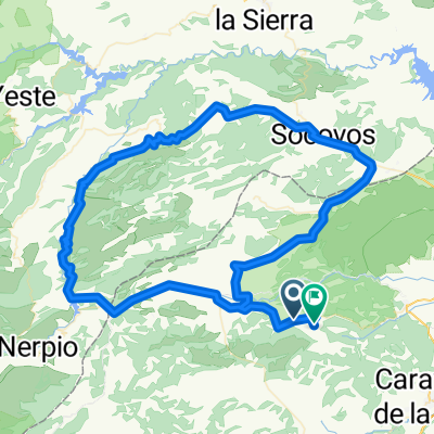
Ruta Pre-Moratallla 2016
A cycling route starting in Moratalla, Murcia, Spain.
Overview
About this route
Entreno oficial 7/05/2016
Inicio 8h30'...Desde Campo de Bejar
Final: La Pava
- -:--
- Duration
- 117.7 km
- Distance
- 1,339 m
- Ascent
- 1,362 m
- Descent
- ---
- Avg. speed
- ---
- Avg. speed
Route quality
Waytypes & surfaces along the route
Waytypes
Busy road
62.3 km
(53 %)
Road
31.4 km
(27 %)
Surfaces
Paved
87 km
(74 %)
Unpaved
0.2 km
(<1 %)
Asphalt
87 km
(74 %)
Gravel
0.2 km
(<1 %)
Undefined
30.5 km
(26 %)
Continue with Bikemap
Use, edit, or download this cycling route
You would like to ride Ruta Pre-Moratallla 2016 or customize it for your own trip? Here is what you can do with this Bikemap route:
Free features
- Save this route as favorite or in collections
- Copy & plan your own version of this route
- Sync your route with Garmin or Wahoo
Premium features
Free trial for 3 days, or one-time payment. More about Bikemap Premium.
- Navigate this route on iOS & Android
- Export a GPX / KML file of this route
- Create your custom printout (try it for free)
- Download this route for offline navigation
Discover more Premium features.
Get Bikemap PremiumFrom our community
Other popular routes starting in Moratalla
- Nº36 Moratalla,Tazona,Socovos, Colas del Cenajo, Elche,Férez,Titoabuelito
- Distance
- 126.4 km
- Ascent
- 1,232 m
- Descent
- 1,232 m
- Location
- Moratalla, Murcia, Spain
- Moratalla - Finisterre
- Distance
- 1,745.6 km
- Ascent
- 2,876 m
- Descent
- 3,481 m
- Location
- Moratalla, Murcia, Spain
- Nº21 Moratalla Cenajo Socovos Benizar San Juan Titoabuelito
- Distance
- 124.7 km
- Ascent
- 1,510 m
- Descent
- 1,471 m
- Location
- Moratalla, Murcia, Spain
- Nº34 Moratalla, Calasparra, CehegÃn, Caravaca, archivel, Titoabuelito
- Distance
- 107.5 km
- Ascent
- 1,137 m
- Descent
- 1,130 m
- Location
- Moratalla, Murcia, Spain
- Previa de Moratalla 2014
- Distance
- 125.1 km
- Ascent
- 1,501 m
- Descent
- 1,498 m
- Location
- Moratalla, Murcia, Spain
- Steady ride
- Distance
- 97.4 km
- Ascent
- 2,196 m
- Descent
- 1,878 m
- Location
- Moratalla, Murcia, Spain
- Nº37 Moratalla,El sabinar,Zaen,Archivel,Barranda,Almudema,Caravaca,Titoabuelito
- Distance
- 95.5 km
- Ascent
- 992 m
- Descent
- 1,014 m
- Location
- Moratalla, Murcia, Spain
- Ruta Pre-Moratallla 2016
- Distance
- 117.7 km
- Ascent
- 1,339 m
- Descent
- 1,362 m
- Location
- Moratalla, Murcia, Spain
Open it in the app