
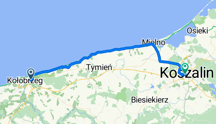
Kołobrzeg - Koszalin (nadmorska)
A cycling route starting in Kołobrzeg, West Pomeranian Voivodeship, Poland.
Overview
About this route
p. Sianożęty, Ustronie Morskie, Pleśna, Gąski, Sarbinowo, Chłopy, Mielno, Strzeżenice, Mścice
- -:--
- Duration
- 47.7 km
- Distance
- 110 m
- Ascent
- 82 m
- Descent
- ---
- Avg. speed
- ---
- Max. altitude

Route quality
Waytypes & surfaces along the route
Waytypes
Path
17.2 km
(36 %)
Cycleway
12.4 km
(26 %)
Surfaces
Paved
36.2 km
(76 %)
Unpaved
1.4 km
(3 %)
Asphalt
33.4 km
(70 %)
Concrete
2.4 km
(5 %)
Continue with Bikemap
Use, edit, or download this cycling route
You would like to ride Kołobrzeg - Koszalin (nadmorska) or customize it for your own trip? Here is what you can do with this Bikemap route:
Free features
- Save this route as favorite or in collections
- Copy & plan your own version of this route
- Sync your route with Garmin or Wahoo
Premium features
Free trial for 3 days, or one-time payment. More about Bikemap Premium.
- Navigate this route on iOS & Android
- Export a GPX / KML file of this route
- Create your custom printout (try it for free)
- Download this route for offline navigation
Discover more Premium features.
Get Bikemap PremiumFrom our community
Other popular routes starting in Kołobrzeg
 Kołobrzeg-Mrzeżyno-Kołobrzeg
- Distance
- 44.2 km
- Ascent
- 3 m
- Descent
- 0 m
- Location
- Kołobrzeg, West Pomeranian Voivodeship, Poland
 Fredry, Kołobrzeg do Turystyczna 11a, Dąbki
- Distance
- 65.7 km
- Ascent
- 93 m
- Descent
- 99 m
- Location
- Kołobrzeg, West Pomeranian Voivodeship, Poland
 Szlak solny
- Distance
- 31.2 km
- Ascent
- 103 m
- Descent
- 70 m
- Location
- Kołobrzeg, West Pomeranian Voivodeship, Poland
 Kołobrzeg - Charzyno - Siemyśl - Trzynik - Ząbrowo - Pustary - Niekanin - Kołobrzeg
- Distance
- 48.5 km
- Ascent
- 139 m
- Descent
- 139 m
- Location
- Kołobrzeg, West Pomeranian Voivodeship, Poland
 Kołobrzeg Dźwirzyno
- Distance
- 39.1 km
- Ascent
- 59 m
- Descent
- 56 m
- Location
- Kołobrzeg, West Pomeranian Voivodeship, Poland
 Wycieczka nr 13 pt 1
- Distance
- 34.8 km
- Ascent
- 534 m
- Descent
- 482 m
- Location
- Kołobrzeg, West Pomeranian Voivodeship, Poland
 Jeziora Kamienica i Popiel
- Distance
- 61.6 km
- Ascent
- 183 m
- Descent
- 152 m
- Location
- Kołobrzeg, West Pomeranian Voivodeship, Poland
 Okolice Kołobrzegu
- Distance
- 29.7 km
- Ascent
- 110 m
- Descent
- 112 m
- Location
- Kołobrzeg, West Pomeranian Voivodeship, Poland
Open it in the app