
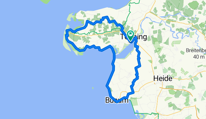
NF 002: Rundkurs Eiderstedt und Büsum
A cycling route starting in Friedrichstadt, Schleswig-Holstein, Germany.
Overview
About this route
Tönning - Poppenbüll - Südheverkoog - Sankt Peter-Ording - Eidersperrw. - Büsum - Friedrichsgabekoog - Wesselburener Deichhausen - Hassenbüttel - Jarrenwisch - Wulfenhusen - Tödienwisch - Strübbel - Zennhusen - Eiderbrücke/B5 - Tönning
- -:--
- Duration
- 109.8 km
- Distance
- 4 m
- Ascent
- 5 m
- Descent
- ---
- Avg. speed
- ---
- Avg. speed
Route quality
Waytypes & surfaces along the route
Waytypes
Quiet road
29.3 km
(27 %)
Track
20.4 km
(19 %)
Surfaces
Paved
80.8 km
(74 %)
Unpaved
1.2 km
(1 %)
Asphalt
68.9 km
(63 %)
Concrete
5 km
(5 %)
Route highlights
Points of interest along the route
Photo after 61.5 km
Eidersperrwerk
Drinking water after 61.7 km
Eider
Photo after 96.8 km
Heider Marktplatz
Drinking water after 106.8 km
Treene
Drinking water after 106.8 km
Eider
Photo after 106.8 km
St. Christiphorus
Photo after 106.8 km
Roter Haubarg
Drinking water after 106.8 km
Ostersielzug
Drinking water after 106.8 km
Treene
Continue with Bikemap
Use, edit, or download this cycling route
You would like to ride NF 002: Rundkurs Eiderstedt und Büsum or customize it for your own trip? Here is what you can do with this Bikemap route:
Free features
- Save this route as favorite or in collections
- Copy & plan your own version of this route
- Split it into stages to create a multi-day tour
- Sync your route with Garmin or Wahoo
Premium features
Free trial for 3 days, or one-time payment. More about Bikemap Premium.
- Navigate this route on iOS & Android
- Export a GPX / KML file of this route
- Create your custom printout (try it for free)
- Download this route for offline navigation
Discover more Premium features.
Get Bikemap PremiumFrom our community
Other popular routes starting in Friedrichstadt
 Friedrichstadt-Eider-Sorge-Treene
- Distance
- 70.1 km
- Ascent
- 43 m
- Descent
- 45 m
- Location
- Friedrichstadt, Schleswig-Holstein, Germany
 Nordsee 13: Friedrichstadt-Tellingstedt 70,4km 80hm
- Distance
- 70.4 km
- Ascent
- 139 m
- Descent
- 126 m
- Location
- Friedrichstadt, Schleswig-Holstein, Germany
 Eider-Treene-Sorge Weg
- Distance
- 233.2 km
- Ascent
- 184 m
- Descent
- 187 m
- Location
- Friedrichstadt, Schleswig-Holstein, Germany
 Deutschland R2
- Distance
- 754.5 km
- Ascent
- 817 m
- Descent
- 697 m
- Location
- Friedrichstadt, Schleswig-Holstein, Germany
 Friedrichstadt-Schwabstedt 18,6 km
- Distance
- 18.6 km
- Ascent
- 10 m
- Descent
- 12 m
- Location
- Friedrichstadt, Schleswig-Holstein, Germany
 Nordsee 13a: Friedrichstadt-Halebüll 51,1km 0hm
- Distance
- 51.1 km
- Ascent
- 24 m
- Descent
- 24 m
- Location
- Friedrichstadt, Schleswig-Holstein, Germany
 Friedrichstadt-Husum Rund
- Distance
- 44.8 km
- Ascent
- 33 m
- Descent
- 33 m
- Location
- Friedrichstadt, Schleswig-Holstein, Germany
 1.Bahnhof Friedrichstadt-Sehenswürdigkeiten-Kropp Hotel
- Distance
- 40.4 km
- Ascent
- 59 m
- Descent
- 47 m
- Location
- Friedrichstadt, Schleswig-Holstein, Germany
Open it in the app