
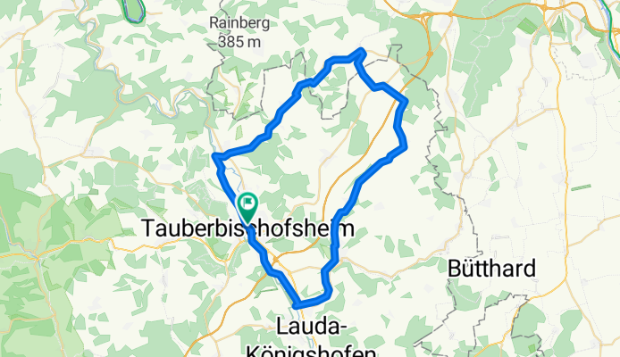
Tauber-Welzbach-Grünbach-Tauber
A cycling route starting in Tauberbischofsheim, Baden-Wurttemberg, Germany.
Overview
About this route
Tauberbischofsheim-Hochhausen-Werbach-Werbachhausen-Wenkheim-Unteraltertheim-Oberaltertheim-Gerchsheim-Schönfeld-Ilmspan-Paimar-Grünsfeld-Gerlachsheim-Tauberbischofsheim
- -:--
- Duration
- 49.6 km
- Distance
- 260 m
- Ascent
- 258 m
- Descent
- ---
- Avg. speed
- ---
- Max. altitude
Route quality
Waytypes & surfaces along the route
Waytypes
Track
22.1 km
(45 %)
Quiet road
17.7 km
(36 %)
Surfaces
Paved
43.4 km
(87 %)
Unpaved
0.1 km
(<1 %)
Asphalt
37.7 km
(76 %)
Paved (undefined)
5.7 km
(11 %)
Route highlights
Points of interest along the route
Point of interest after 35.6 km
Achatiuskapelle
Continue with Bikemap
Use, edit, or download this cycling route
You would like to ride Tauber-Welzbach-Grünbach-Tauber or customize it for your own trip? Here is what you can do with this Bikemap route:
Free features
- Save this route as favorite or in collections
- Copy & plan your own version of this route
- Sync your route with Garmin or Wahoo
Premium features
Free trial for 3 days, or one-time payment. More about Bikemap Premium.
- Navigate this route on iOS & Android
- Export a GPX / KML file of this route
- Create your custom printout (try it for free)
- Download this route for offline navigation
Discover more Premium features.
Get Bikemap PremiumFrom our community
Other popular routes starting in Tauberbischofsheim
 Gemütliche Route in Tauberbischofsheim
- Distance
- 9.1 km
- Ascent
- 260 m
- Descent
- 266 m
- Location
- Tauberbischofsheim, Baden-Wurttemberg, Germany
 TBB Wertheim auf MD-Weg über Urphar zurück
- Distance
- 56.9 km
- Ascent
- 789 m
- Descent
- 790 m
- Location
- Tauberbischofsheim, Baden-Wurttemberg, Germany
 AOK-Radtour-Tag 1
- Distance
- 56.9 km
- Ascent
- 778 m
- Descent
- 779 m
- Location
- Tauberbischofsheim, Baden-Wurttemberg, Germany
 Mountainbikerunde TBB-Grünsfeld-Lauda
- Distance
- 38.9 km
- Ascent
- 671 m
- Descent
- 673 m
- Location
- Tauberbischofsheim, Baden-Wurttemberg, Germany
 UT 08-2023: Tauberbischofsheim - Miltenberg
- Distance
- 62.8 km
- Ascent
- 427 m
- Descent
- 476 m
- Location
- Tauberbischofsheim, Baden-Wurttemberg, Germany
 Lange Ausfahrt durch Taubertal
- Distance
- 40.1 km
- Ascent
- 118 m
- Descent
- 118 m
- Location
- Tauberbischofsheim, Baden-Wurttemberg, Germany
 Bierliebhaber Rundkurs
- Distance
- 29.5 km
- Ascent
- 581 m
- Descent
- 532 m
- Location
- Tauberbischofsheim, Baden-Wurttemberg, Germany
 Tauber-Welzbach-Grünbach-Tauber
- Distance
- 49.6 km
- Ascent
- 260 m
- Descent
- 258 m
- Location
- Tauberbischofsheim, Baden-Wurttemberg, Germany
Open it in the app