
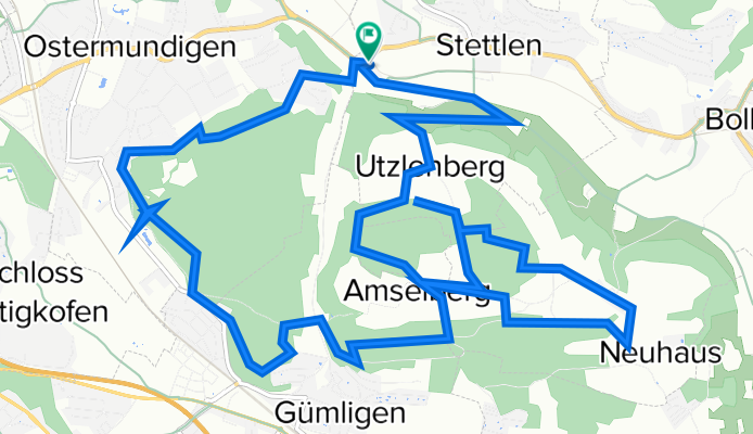
Deisswil - Dentenberg - Ostermundigenberg
A cycling route starting in Stettlen, Canton of Bern, Switzerland.
Overview
About this route
Many singletrails on the Dentenberg and also many variations on the Ostermundigenberg.
- -:--
- Duration
- 17.8 km
- Distance
- 377 m
- Ascent
- 377 m
- Descent
- ---
- Avg. speed
- ---
- Max. altitude

Route quality
Waytypes & surfaces along the route
Waytypes
Track
7.3 km
(41 %)
Quiet road
6.9 km
(39 %)
Surfaces
Paved
7.3 km
(41 %)
Unpaved
8.7 km
(49 %)
Asphalt
7.1 km
(40 %)
Gravel
4.6 km
(26 %)
Continue with Bikemap
Use, edit, or download this cycling route
You would like to ride Deisswil - Dentenberg - Ostermundigenberg or customize it for your own trip? Here is what you can do with this Bikemap route:
Free features
- Save this route as favorite or in collections
- Copy & plan your own version of this route
- Sync your route with Garmin or Wahoo
Premium features
Free trial for 3 days, or one-time payment. More about Bikemap Premium.
- Navigate this route on iOS & Android
- Export a GPX / KML file of this route
- Create your custom printout (try it for free)
- Download this route for offline navigation
Discover more Premium features.
Get Bikemap PremiumFrom our community
Other popular routes starting in Stettlen
 Rainweg 2, Stettlen nach Oberdorfstrasse 17, Stettlen
- Distance
- 28.1 km
- Ascent
- 328 m
- Descent
- 374 m
- Location
- Stettlen, Canton of Bern, Switzerland
 Final Bantiger
- Distance
- 5.5 km
- Ascent
- 391 m
- Descent
- 7 m
- Location
- Stettlen, Canton of Bern, Switzerland
 bantiger
- Distance
- 21 km
- Ascent
- 554 m
- Descent
- 529 m
- Location
- Stettlen, Canton of Bern, Switzerland
 cooool
- Distance
- 39 km
- Ascent
- 639 m
- Descent
- 667 m
- Location
- Stettlen, Canton of Bern, Switzerland
 uhu1969
- Distance
- 86.7 km
- Ascent
- 1,969 m
- Descent
- 1,582 m
- Location
- Stettlen, Canton of Bern, Switzerland
 Hohliebiweg 8, Vechigen nach Rue Estelle 6, Marseille
- Distance
- 838 km
- Ascent
- 15,827 m
- Descent
- 16,489 m
- Location
- Stettlen, Canton of Bern, Switzerland
 Stettlen - Thun - Stettlen
- Distance
- 110.9 km
- Ascent
- 336 m
- Descent
- 338 m
- Location
- Stettlen, Canton of Bern, Switzerland
 Bern Bielersee Neuenb.See - Lyss
- Distance
- 181.7 km
- Ascent
- 472 m
- Descent
- 648 m
- Location
- Stettlen, Canton of Bern, Switzerland
Open it in the app