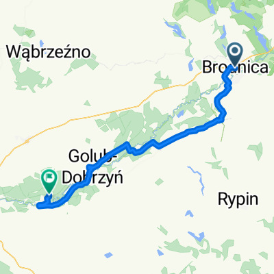
VVBrodnickie-maj贸wka1
A cycling route starting in Brodnica, Kujawsko-Pomorskie Voivodship, Poland.
Overview
About this route
- -:--
 - Duration
 - 38.9 km
 - Distance
 - 227 m
 - Ascent
 - 226 m
 - Descent
 - ---
 - Avg. speed
 - ---
 - Max. altitude
 
Route quality
Waytypes & surfaces along the route
Waytypes
Road
18.3 km
(47 %)
Quiet road
10.1 km
(26 %)
Surfaces
Paved
32.3 km
(83 %)
Unpaved
4.7 km
(12 %)
Asphalt
25.3 km
(65 %)
Paved (undefined)
7 km
(18 %)
Continue with Bikemap
Use, edit, or download this cycling route
You would like to ride VVBrodnickie-maj贸wka1 or customize it for your own trip? Here is what you can do with this Bikemap route:
Free features
- Save this route as favorite or in collections
 - Copy & plan your own version of this route
 - Sync your route with Garmin or Wahoo
 
Premium features
Free trial for 3 days, or one-time payment. More about Bikemap Premium.
- Navigate this route on iOS & Android
 - Export a GPX / KML file of this route
 - Create your custom printout (try it for free)
 - Download this route for offline navigation
 
Discover more Premium features.
Get Bikemap PremiumFrom our community
Other popular routes starting in Brodnica
S 呕eromskiego, Brodnica to 18 Stycznia, Brodnica- Distance
 - 25.3 km
 - Ascent
 - 554 m
 - Descent
 - 551 m
 - Location
 - Brodnica, Kujawsko-Pomorskie Voivodship, Poland
 
Brodnica-Jezioro Forbin- Distance
 - 19.1 km
 - Ascent
 - 579 m
 - Descent
 - 576 m
 - Location
 - Brodnica, Kujawsko-Pomorskie Voivodship, Poland
 
VVBrodnickie-maj贸wka1- Distance
 - 38.9 km
 - Ascent
 - 227 m
 - Descent
 - 226 m
 - Location
 - Brodnica, Kujawsko-Pomorskie Voivodship, Poland
 
Brodnickie1-2017- Distance
 - 30.9 km
 - Ascent
 - 224 m
 - Descent
 - 213 m
 - Location
 - Brodnica, Kujawsko-Pomorskie Voivodship, Poland
 
VVBrodnickie-maj贸wka2+p臋tlaRez.Retno- Distance
 - 56.9 km
 - Ascent
 - 282 m
 - Descent
 - 285 m
 - Location
 - Brodnica, Kujawsko-Pomorskie Voivodship, Poland
 
OR TORU艃 26.06- Distance
 - 53.7 km
 - Ascent
 - 318 m
 - Descent
 - 312 m
 - Location
 - Brodnica, Kujawsko-Pomorskie Voivodship, Poland
 
68D to 68D- Distance
 - 24.5 km
 - Ascent
 - 158 m
 - Descent
 - 158 m
 - Location
 - Brodnica, Kujawsko-Pomorskie Voivodship, Poland
 
Brodnickie2-2017- Distance
 - 48.1 km
 - Ascent
 - 285 m
 - Descent
 - 288 m
 - Location
 - Brodnica, Kujawsko-Pomorskie Voivodship, Poland
 
Open it in the app


