
Route to Tres Picos de Salinas
A cycling route starting in Cachoeiras de Macacu, State of Rio de Janeiro, Brazil.
Overview
About this route
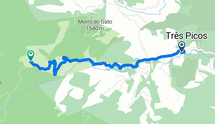
This is the route to the base camp to Tres Picos de Salinas, one of the most impressive mountains group near Rio de Janeiro. The track starts at Trutas Arco Iris Restaurant, where you can enjoy delightful trouts in this small restaurant run by the owners.
The end is near a mountain hut (opening schedule is random) at several trailheads to the nearby mountains summits.
- -:--
- Duration
- 4.1 km
- Distance
- 532 m
- Ascent
- 86 m
- Descent
- ---
- Avg. speed
- ---
- Avg. speed

Continue with Bikemap
Use, edit, or download this cycling route
You would like to ride Route to Tres Picos de Salinas or customize it for your own trip? Here is what you can do with this Bikemap route:
Free features
- Save this route as favorite or in collections
- Copy & plan your own version of this route
- Sync your route with Garmin or Wahoo
Premium features
Free trial for 3 days, or one-time payment. More about Bikemap Premium.
- Navigate this route on iOS & Android
- Export a GPX / KML file of this route
- Create your custom printout (try it for free)
- Download this route for offline navigation
Discover more Premium features.
Get Bikemap PremiumFrom our community
Other popular routes starting in Cachoeiras de Macacu
 G.U.T - Giro Urbano de Treino
- Distance
- 11.5 km
- Ascent
- 438 m
- Descent
- 438 m
- Location
- Cachoeiras de Macacu, State of Rio de Janeiro, Brazil
 CicloTour 01 - Cachoeiras: Centro X Tocas X Castalia X Valerio
- Distance
- 10.2 km
- Ascent
- 354 m
- Descent
- 356 m
- Location
- Cachoeiras de Macacu, State of Rio de Janeiro, Brazil
 Rota FelipeBarroso / Cachoeiras - Centro x Faraó x Japuiba x Papucaia - Ruína do Convento da Santíssima Trindade
- Distance
- 24.9 km
- Ascent
- 69 m
- Descent
- 110 m
- Location
- Cachoeiras de Macacu, State of Rio de Janeiro, Brazil
 Cachoeiras de Macacu X Tocas
- Distance
- 10.1 km
- Ascent
- 321 m
- Descent
- 323 m
- Location
- Cachoeiras de Macacu, State of Rio de Janeiro, Brazil
 Rota FelipeBarroso / Cachoeiras - Centro x Ruína da Igreja de São José da Boa Morte
- Distance
- 28.6 km
- Ascent
- 203 m
- Descent
- 242 m
- Location
- Cachoeiras de Macacu, State of Rio de Janeiro, Brazil
 Ciclogiro Macacu - 100 Km Cachoeiras de Macacu
- Distance
- 99.3 km
- Ascent
- 291 m
- Descent
- 291 m
- Location
- Cachoeiras de Macacu, State of Rio de Janeiro, Brazil
 Ciclomacacu - 1º Circuito Rolé Urbano Macacu ( RUMA )
- Distance
- 7 km
- Ascent
- 131 m
- Descent
- 133 m
- Location
- Cachoeiras de Macacu, State of Rio de Janeiro, Brazil
 CicloNoel - Pedal Noturno
- Distance
- 12.7 km
- Ascent
- 341 m
- Descent
- 359 m
- Location
- Cachoeiras de Macacu, State of Rio de Janeiro, Brazil
Open it in the app