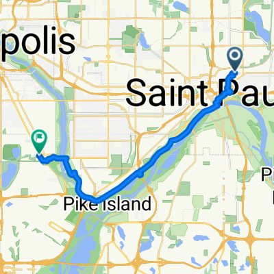
B2B00024 55104 > 55121 via Big Rivers Trail
A cycling route starting in Saint Paul, Minnesota, United States.
Overview
About this route
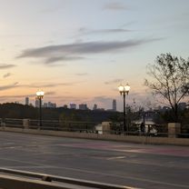
<span style="font-size: 6pt; color: #535353; font-family: "Verdana","sans-serif";">Once we get to the 35E Bridge bikeway, follow one of the nicest bike trails in the TC area. </span>
<span style="font-size: 6pt; color: #535353; font-family: "Verdana","sans-serif";"> </span>
<span style="font-size: 6pt; color: #535353; font-family: "Verdana","sans-serif";">Expect hills with any perpendicular travel to the River. And the contrary… nice and flat traveling with the River.</span>
- -:--
- Duration
- 16.8 km
- Distance
- 174 m
- Ascent
- 174 m
- Descent
- ---
- Avg. speed
- ---
- Max. altitude
Route highlights
Points of interest along the route
Point of interest after 3.1 km
Pick up trail at end of Palace
Point of interest after 5.7 km
Cross Shepard and onto trail. Trail follows west side of 35E, then thru tunnel.
Continue with Bikemap
Use, edit, or download this cycling route
You would like to ride B2B00024 55104 > 55121 via Big Rivers Trail or customize it for your own trip? Here is what you can do with this Bikemap route:
Free features
- Save this route as favorite or in collections
- Copy & plan your own version of this route
- Sync your route with Garmin or Wahoo
Premium features
Free trial for 3 days, or one-time payment. More about Bikemap Premium.
- Navigate this route on iOS & Android
- Export a GPX / KML file of this route
- Create your custom printout (try it for free)
- Download this route for offline navigation
Discover more Premium features.
Get Bikemap PremiumFrom our community
Other popular routes starting in Saint Paul
B2B00062 55106 - 55075 via Concord, NURT- Distance
- 9.5 km
- Ascent
- 80 m
- Descent
- 110 m
- Location
- Saint Paul, Minnesota, United States
B2B00418 55117>55123 via Cedar, Wabasha, Lexington, Pilot Knob Rd- Distance
- 20.8 km
- Ascent
- 161 m
- Descent
- 156 m
- Location
- Saint Paul, Minnesota, United States
Relaxed route in Saint Paul- Distance
- 23 km
- Ascent
- 110 m
- Descent
- 101 m
- Location
- Saint Paul, Minnesota, United States
To the River Center- Distance
- 17.1 km
- Ascent
- 117 m
- Descent
- 90 m
- Location
- Saint Paul, Minnesota, United States
B2B00192 55102>55404viaShepherdRd/MissBlvd/WRiverPkwy/MidtwnGrnway- Distance
- 21.8 km
- Ascent
- 131 m
- Descent
- 86 m
- Location
- Saint Paul, Minnesota, United States
Gateway State Trail- Distance
- 30 km
- Ascent
- 115 m
- Descent
- 69 m
- Location
- Saint Paul, Minnesota, United States
From Saint Paul to Minneapolis- Distance
- 19.2 km
- Ascent
- 179 m
- Descent
- 191 m
- Location
- Saint Paul, Minnesota, United States
Jackson Street to East 7th Street- Distance
- 1.6 km
- Ascent
- 36 m
- Descent
- 0 m
- Location
- Saint Paul, Minnesota, United States
Open it in the app

