

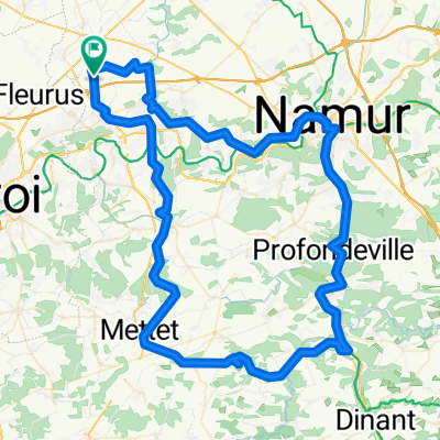
Relais de Charlinette-Relais de Charlinette
A cycling route starting in Sombreffe, Wallonia, Belgium.
Overview
About this route
- -:--
- Duration
- 99.6 km
- Distance
- 530 m
- Ascent
- 532 m
- Descent
- ---
- Avg. speed
- ---
- Max. altitude

Route quality
Waytypes & surfaces along the route
Waytypes
Cycleway
39.3 km
(39 %)
Quiet road
22.6 km
(23 %)
Surfaces
Paved
32.9 km
(33 %)
Unpaved
4.2 km
(4 %)
Asphalt
26 km
(26 %)
Gravel
3.6 km
(4 %)
Route highlights
Points of interest along the route
Point of interest after 49.9 km
Chateau
Point of interest after 49.9 km
Celles
Point of interest after 49.9 km
Ciney
Point of interest after 49.9 km
Chateau de Veves
Point of interest after 49.9 km
Chateau des conjoux
Point of interest after 49.9 km
Diant
Point of interest after 63.2 km
Maredsous
Continue with Bikemap
Use, edit, or download this cycling route
You would like to ride Relais de Charlinette-Relais de Charlinette or customize it for your own trip? Here is what you can do with this Bikemap route:
Free features
- Save this route as favorite or in collections
- Copy & plan your own version of this route
- Split it into stages to create a multi-day tour
- Sync your route with Garmin or Wahoo
Premium features
Free trial for 3 days, or one-time payment. More about Bikemap Premium.
- Navigate this route on iOS & Android
- Export a GPX / KML file of this route
- Create your custom printout (try it for free)
- Download this route for offline navigation
Discover more Premium features.
Get Bikemap PremiumFrom our community
Other popular routes starting in Sombreffe
 Tongrinne -> Onhaye
- Distance
- 44.4 km
- Ascent
- 423 m
- Descent
- 379 m
- Location
- Sombreffe, Wallonia, Belgium
 77 kil from Sombreffe
- Distance
- 77.3 km
- Ascent
- 383 m
- Descent
- 383 m
- Location
- Sombreffe, Wallonia, Belgium
 Relais de Charlinette-Relais de Charlinette
- Distance
- 99.6 km
- Ascent
- 530 m
- Descent
- 532 m
- Location
- Sombreffe, Wallonia, Belgium
 Promenade autour du Gembloux
- Distance
- 47.5 km
- Ascent
- 373 m
- Descent
- 372 m
- Location
- Sombreffe, Wallonia, Belgium
 Petit décrassage hivernal
- Distance
- 28 km
- Ascent
- 194 m
- Descent
- 192 m
- Location
- Sombreffe, Wallonia, Belgium
 Long training run - about length of étape route
- Distance
- 148 km
- Ascent
- 614 m
- Descent
- 617 m
- Location
- Sombreffe, Wallonia, Belgium
 rue des mélèze ixelles
- Distance
- 54.5 km
- Ascent
- 462 m
- Descent
- 509 m
- Location
- Sombreffe, Wallonia, Belgium
 Promenade lente
- Distance
- 155 km
- Ascent
- 649 m
- Descent
- 762 m
- Location
- Sombreffe, Wallonia, Belgium
Open it in the app