

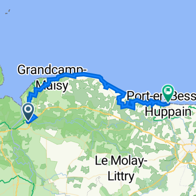
Géfosse-Fontenay - Pointe Hoc, 30km
A cycling route starting in Isigny-sur-Mer, Normandy, France.
Overview
About this route
- -:--
- Duration
- 30.8 km
- Distance
- 77 m
- Ascent
- 77 m
- Descent
- ---
- Avg. speed
- ---
- Max. altitude
Continue with Bikemap
Use, edit, or download this cycling route
You would like to ride Géfosse-Fontenay - Pointe Hoc, 30km or customize it for your own trip? Here is what you can do with this Bikemap route:
Free features
- Save this route as favorite or in collections
- Copy & plan your own version of this route
- Sync your route with Garmin or Wahoo
Premium features
Free trial for 3 days, or one-time payment. More about Bikemap Premium.
- Navigate this route on iOS & Android
- Export a GPX / KML file of this route
- Create your custom printout (try it for free)
- Download this route for offline navigation
Discover more Premium features.
Get Bikemap PremiumFrom our community
Other popular routes starting in Isigny-sur-Mer
 Géfosse-Fontenay - Pointe Hoc, 30km
- Distance
- 30.8 km
- Ascent
- 77 m
- Descent
- 77 m
- Location
- Isigny-sur-Mer, Normandy, France
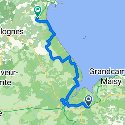
 Les Marais de l'Aure
- Distance
- 30.4 km
- Ascent
- 115 m
- Descent
- 114 m
- Location
- Isigny-sur-Mer, Normandy, France
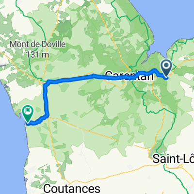
 Isigny - Port en Bessin
- Distance
- 47.1 km
- Ascent
- 309 m
- Descent
- 310 m
- Location
- Isigny-sur-Mer, Normandy, France
 Isgny-sur-Mer to Omaha
- Distance
- 39.5 km
- Ascent
- 226 m
- Descent
- 170 m
- Location
- Isigny-sur-Mer, Normandy, France
 Route Rupalley nach Chemin des Sabions
- Distance
- 48.9 km
- Ascent
- 204 m
- Descent
- 221 m
- Location
- Isigny-sur-Mer, Normandy, France
 Mon Tour de France - Etape 5
- Distance
- 98.4 km
- Ascent
- 516 m
- Descent
- 508 m
- Location
- Isigny-sur-Mer, Normandy, France
 Isigny-sur-Mer - Quettehou
- Distance
- 57.1 km
- Ascent
- 156 m
- Descent
- 124 m
- Location
- Isigny-sur-Mer, Normandy, France
 Cérisy-la-Forêt_70,6km_270hm
- Distance
- 70.6 km
- Ascent
- 226 m
- Descent
- 225 m
- Location
- Isigny-sur-Mer, Normandy, France
Open it in the app