

Forni di Sopra, Anello Tagliamento
A cycling route starting in Vico, Friuli Venezia Giulia, Italy.
Overview
About this route
LOOP ALONG THE TAGLIAMENTO
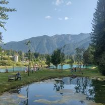
Beautiful valley walk with minimal elevation changes, suitable for families with children and school groups, with numerous natural and historical points of interest. The starting point is directly behind the ponds in the locality of Davost along a trail that is not marked by CAI but is wide, obvious, and well-frequented.
With the Tagliamento on the left, you reach a first geologically interesting point: an outcrop of gypsum rocks that creates a landslide-prone and unstable slope.
Several interesting works of natural engineering have been carried out in this area, showing how one can operate non-invasively on the land.
The trail narrows but remains visible; it crosses a few small streams and passes near some stavoli, some of which have been restored as holiday homes.
In these places, one can read the history of a mountain area: the phases of pasturing with the first grazing along the slopes of the village, the abandonment of these areas leading to the often uncontrolled regrowth of the forest, the varieties of fruit trees that grew near the farmhouses.
On reaching a bridge, you cross it to walk a short section on an asphalted road until another bridge is reached, where you cross again to take the forest road southeast (the river remains on our left).
After a few dozen meters, there is a large anthill of Formica rufa on the right and shortly after a small bog rich in interesting floral and fauna species.
Often, these small wetlands are among the main reservoirs of biodiversity in the mountainous territory.
Continuing, you arrive at the farmhouses and meadows of Località Piniei: one of the most open and panoramic meadows in the Fornese area.
Continuing along the forest road, one enters the beech forests of the valley floor, whose visit is particularly recommended in spring and winter for their incomparable colors.
For the return, follow the mountain bike route that enters the beech forest (watch for the colored markers) and then remerges on the dirt road just before the locality of Piniei.
To vary the return, once at the first bridge crossed on the way out, it is advisable to follow the path on the other side of the river or climb to the Borgo of Andrazza, which is absolutely worth a visit for its architectural integrity.
NOTES:
Municipality: Forni di Sopra
Departure: Parking at the Sports Center area Davost, Forni di Sopra (878 m a.s.l.)
Arrival: Parking at the Sports Center area Davost
Recommended period: all year round, even with snowshoes in winter
Indicative travel time: 5-6 hours
Features:
Geographical and ethnographic (land management, spontaneous architectures)
Geomorphological (exposures of gypsum, river erosion phenomena)
Points of interest: Tagliamento River, meadows and stavoli in the locality of Piniei, waterfall Val Rovedia
Cartography: Ed. Tabacco Map of the Natural Park of the Friulian Dolomites and Ed. Tabacco n. 021
Support points: Absent, various possibilities for early return
- -:--
- Duration
- 9.3 km
- Distance
- 146 m
- Ascent
- 159 m
- Descent
- ---
- Avg. speed
- ---
- Max. altitude

Continue with Bikemap
Use, edit, or download this cycling route
You would like to ride Forni di Sopra, Anello Tagliamento or customize it for your own trip? Here is what you can do with this Bikemap route:
Free features
- Save this route as favorite or in collections
- Copy & plan your own version of this route
- Sync your route with Garmin or Wahoo
Premium features
Free trial for 3 days, or one-time payment. More about Bikemap Premium.
- Navigate this route on iOS & Android
- Export a GPX / KML file of this route
- Create your custom printout (try it for free)
- Download this route for offline navigation
Discover more Premium features.
Get Bikemap PremiumFrom our community
Other popular routes starting in Vico
 Zoncolan da Ovaro
- Distance
- 111.8 km
- Ascent
- 2,177 m
- Descent
- 2,177 m
- Location
- Vico, Friuli Venezia Giulia, Italy
 Forni di Sopra - Piniei, percorso mountain & fatbike
- Distance
- 22.4 km
- Ascent
- 329 m
- Descent
- 329 m
- Location
- Vico, Friuli Venezia Giulia, Italy
 Forni di Sopra - Piniei, percorso mountain bike
- Distance
- 22.4 km
- Ascent
- 327 m
- Descent
- 327 m
- Location
- Vico, Friuli Venezia Giulia, Italy
 sella Bivera da Casera Razzo
- Distance
- 14.4 km
- Ascent
- 1,945 m
- Descent
- 1,982 m
- Location
- Vico, Friuli Venezia Giulia, Italy
 "La Tagliamento"
- Distance
- 179.3 km
- Ascent
- 342 m
- Descent
- 1,547 m
- Location
- Vico, Friuli Venezia Giulia, Italy
 forni di sopra
- Distance
- 5.4 km
- Ascent
- 590 m
- Descent
- 158 m
- Location
- Vico, Friuli Venezia Giulia, Italy
 Malga Tragonia/Tartoi
- Distance
- 13.2 km
- Ascent
- 1,029 m
- Descent
- 228 m
- Location
- Vico, Friuli Venezia Giulia, Italy
 Forni di Sopra - Tartoi - Ridona
- Distance
- 14.4 km
- Ascent
- 802 m
- Descent
- 805 m
- Location
- Vico, Friuli Venezia Giulia, Italy
Open it in the app