
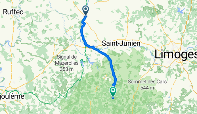
Confolens to La Chapelle-Montbrandeix
A cycling route starting in Confolens, Nouvelle-Aquitaine, France.
Overview
About this route
Option for Chambre d'Hotes on the way to Nontron etc.
- -:--
- Duration
- 55.5 km
- Distance
- 584 m
- Ascent
- 329 m
- Descent
- ---
- Avg. speed
- ---
- Max. altitude

Route quality
Waytypes & surfaces along the route
Waytypes
Quiet road
12.2 km
(22 %)
Road
11.6 km
(21 %)
Surfaces
Paved
31.6 km
(57 %)
Unpaved
1.7 km
(3 %)
Asphalt
31.1 km
(56 %)
Ground
1.7 km
(3 %)
Continue with Bikemap
Use, edit, or download this cycling route
You would like to ride Confolens to La Chapelle-Montbrandeix or customize it for your own trip? Here is what you can do with this Bikemap route:
Free features
- Save this route as favorite or in collections
- Copy & plan your own version of this route
- Sync your route with Garmin or Wahoo
Premium features
Free trial for 3 days, or one-time payment. More about Bikemap Premium.
- Navigate this route on iOS & Android
- Export a GPX / KML file of this route
- Create your custom printout (try it for free)
- Download this route for offline navigation
Discover more Premium features.
Get Bikemap PremiumFrom our community
Other popular routes starting in Confolens
 Confolens to Etagnac longer
- Distance
- 76.8 km
- Ascent
- 991 m
- Descent
- 986 m
- Location
- Confolens, Nouvelle-Aquitaine, France
 Confolens to Etagnac
- Distance
- 64.2 km
- Ascent
- 754 m
- Descent
- 751 m
- Location
- Confolens, Nouvelle-Aquitaine, France
 Confolens to Augignac
- Distance
- 65.7 km
- Ascent
- 514 m
- Descent
- 369 m
- Location
- Confolens, Nouvelle-Aquitaine, France
 Confolens to La Chabroulie, near Saint-Mathieu
- Distance
- 55.2 km
- Ascent
- 519 m
- Descent
- 389 m
- Location
- Confolens, Nouvelle-Aquitaine, France
 To Allue and beyond
- Distance
- 55.5 km
- Ascent
- 640 m
- Descent
- 640 m
- Location
- Confolens, Nouvelle-Aquitaine, France
 De Confolens à D160, Pressignac
- Distance
- 31.3 km
- Ascent
- 423 m
- Descent
- 335 m
- Location
- Confolens, Nouvelle-Aquitaine, France
 Confolence to Civray
- Distance
- 88.5 km
- Ascent
- 837 m
- Descent
- 841 m
- Location
- Confolens, Nouvelle-Aquitaine, France
 Schweiz - Atlantik; 10. Etappe Confolens (Camping Municipal) - Bourg Charante (Camping)
- Distance
- 108.7 km
- Ascent
- 734 m
- Descent
- 828 m
- Location
- Confolens, Nouvelle-Aquitaine, France
Open it in the app