

Schulzendorf-Bunkertour_2
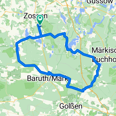
A cycling route starting in Zossen, Brandenburg, Germany.
Overview
About this route
From Schulzendorf through the forests south to Mittenwalde, over Schöneichen to the bunkers in Wünsdorf
- -:--
- Duration
- 29.5 km
- Distance
- 68 m
- Ascent
- 84 m
- Descent
- ---
- Avg. speed
- ---
- Max. altitude
Continue with Bikemap
Use, edit, or download this cycling route
You would like to ride Schulzendorf-Bunkertour_2 or customize it for your own trip? Here is what you can do with this Bikemap route:
Free features
- Save this route as favorite or in collections
- Copy & plan your own version of this route
- Sync your route with Garmin or Wahoo
Premium features
Free trial for 3 days, or one-time payment. More about Bikemap Premium.
- Navigate this route on iOS & Android
- Export a GPX / KML file of this route
- Create your custom printout (try it for free)
- Download this route for offline navigation
Discover more Premium features.
Get Bikemap PremiumFrom our community
Other popular routes starting in Zossen
 perm Glashütte
- Distance
- 78.4 km
- Ascent
- 285 m
- Descent
- 283 m
- Location
- Zossen, Brandenburg, Germany
 Lange Radrunde durch Zossen
- Distance
- 81.6 km
- Ascent
- 134 m
- Descent
- 134 m
- Location
- Zossen, Brandenburg, Germany
 perm Baruther Rund
- Distance
- 83.5 km
- Ascent
- 232 m
- Descent
- 231 m
- Location
- Zossen, Brandenburg, Germany
 Zossen Berlin
- Distance
- 43.7 km
- Ascent
- 51 m
- Descent
- 52 m
- Location
- Zossen, Brandenburg, Germany
 Zossen - Brandenburg
- Distance
- 77.4 km
- Ascent
- 206 m
- Descent
- 217 m
- Location
- Zossen, Brandenburg, Germany
 Rundweg Zossen CLONED FROM ROUTE 144655
- Distance
- 39.2 km
- Ascent
- 108 m
- Descent
- 107 m
- Location
- Zossen, Brandenburg, Germany
 Zossen/Klausdorf/Wünsdorf
- Distance
- 23.4 km
- Ascent
- 20 m
- Descent
- 20 m
- Location
- Zossen, Brandenburg, Germany
 Zossen Mellensee 36 km
- Distance
- 35.6 km
- Ascent
- 79 m
- Descent
- 79 m
- Location
- Zossen, Brandenburg, Germany
Open it in the app