

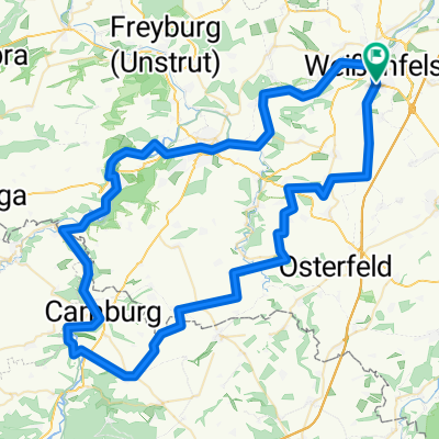
WSF 001: Weißenfelsrunde 1
A cycling route starting in Weißenfels, Saxony-Anhalt, Germany.
Overview
About this route
Weißenfels - Gröbitz - Löbitz - Frauenprießnitz - Wichmar - SAALE - Camburg - SAALE - Bad Kösen - SAALE - NAUMBURG - SAALE - Weißenfels
- -:--
- Duration
- 85.5 km
- Distance
- 436 m
- Ascent
- 436 m
- Descent
- ---
- Avg. speed
- ---
- Max. altitude
Route quality
Waytypes & surfaces along the route
Waytypes
Quiet road
35.9 km
(42 %)
Road
20.5 km
(24 %)
Surfaces
Paved
70.1 km
(82 %)
Unpaved
5.1 km
(6 %)
Asphalt
68.4 km
(80 %)
Gravel
3.4 km
(4 %)
Route highlights
Points of interest along the route
Point of interest after 81.9 km
REWE
Point of interest after 83.7 km
Athos
Point of interest after 84.3 km
E center
Point of interest after 84.3 km
LIDL
Point of interest after 84.4 km
PENNY
Point of interest after 84.4 km
Norma
Drinking water after 84.4 km
Saale
Photo after 84.5 km
Markt
Photo after 84.7 km
Schloss Neu-Augustusburg
Point of interest after 84.8 km
NETTO
Point of interest after 85.4 km
Kaufland
Accommodation after 85.5 km
Parkhotel Güldene Berge
Continue with Bikemap
Use, edit, or download this cycling route
You would like to ride WSF 001: Weißenfelsrunde 1 or customize it for your own trip? Here is what you can do with this Bikemap route:
Free features
- Save this route as favorite or in collections
- Copy & plan your own version of this route
- Split it into stages to create a multi-day tour
- Sync your route with Garmin or Wahoo
Premium features
Free trial for 3 days, or one-time payment. More about Bikemap Premium.
- Navigate this route on iOS & Android
- Export a GPX / KML file of this route
- Create your custom printout (try it for free)
- Download this route for offline navigation
Discover more Premium features.
Get Bikemap PremiumFrom our community
Other popular routes starting in Weißenfels
 WSF 001: Weißenfelsrunde 1
- Distance
- 85.5 km
- Ascent
- 436 m
- Descent
- 436 m
- Location
- Weißenfels, Saxony-Anhalt, Germany
 12 Apostelbrücke
- Distance
- 119.4 km
- Ascent
- 360 m
- Descent
- 360 m
- Location
- Weißenfels, Saxony-Anhalt, Germany
 Südfeldsee und Saaleradweg
- Distance
- 28.9 km
- Ascent
- 167 m
- Descent
- 165 m
- Location
- Weißenfels, Saxony-Anhalt, Germany
 SRW_Etappe7
- Distance
- 68.8 km
- Ascent
- 135 m
- Descent
- 143 m
- Location
- Weißenfels, Saxony-Anhalt, Germany
 Runde2025
- Distance
- 487.1 km
- Ascent
- 3,574 m
- Descent
- 3,573 m
- Location
- Weißenfels, Saxony-Anhalt, Germany
 Weißenfels - Zwickau
- Distance
- 115.3 km
- Ascent
- 559 m
- Descent
- 370 m
- Location
- Weißenfels, Saxony-Anhalt, Germany
 Weißenfels-Bad Kösen-Rehehausen-Apolda
- Distance
- 60.3 km
- Ascent
- 352 m
- Descent
- 271 m
- Location
- Weißenfels, Saxony-Anhalt, Germany
 D11 cheat Weissenfels bis Grafenhainichen
- Distance
- 102.7 km
- Ascent
- 130 m
- Descent
- 136 m
- Location
- Weißenfels, Saxony-Anhalt, Germany
Open it in the app