

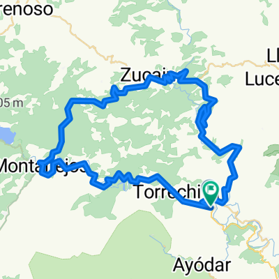
Toga-Argelita-Lucena-Zucaina-Montanejos-Toga
A cycling route starting in Toga, Valencia, Spain.
Overview
About this route
Las etapas que rondan los 2000 metros de altitud acumulada, son para tenerles cierto respeto. En este caso, la mayor dificultad la tenemos al principio, en el puerto Mas del Moro, que sin ser excesiva su dureza, si que se agradece el hacerlo prontito y frescos. Hay dos tramos clásicos rompe-piernas y dos puertos mas que son llevaderos y no tienen dificultad alguna.
- -:--
- Duration
- 97 km
- Distance
- 3,698 m
- Ascent
- 3,679 m
- Descent
- ---
- Avg. speed
- 986 m
- Avg. speed
Route quality
Waytypes & surfaces along the route
Waytypes
Busy road
68 km
(70 %)
Road
23.5 km
(24 %)
Surfaces
Paved
35.5 km
(37 %)
Asphalt
34.9 km
(36 %)
Concrete
0.4 km
(<1 %)
Continue with Bikemap
Use, edit, or download this cycling route
You would like to ride Toga-Argelita-Lucena-Zucaina-Montanejos-Toga or customize it for your own trip? Here is what you can do with this Bikemap route:
Free features
- Save this route as favorite or in collections
- Copy & plan your own version of this route
- Sync your route with Garmin or Wahoo
Premium features
Free trial for 3 days, or one-time payment. More about Bikemap Premium.
- Navigate this route on iOS & Android
- Export a GPX / KML file of this route
- Create your custom printout (try it for free)
- Download this route for offline navigation
Discover more Premium features.
Get Bikemap PremiumFrom our community
Other popular routes starting in Toga
 Toga-Argelita-Lucena-Zucaina-Montanejos-Toga
- Distance
- 97 km
- Ascent
- 3,698 m
- Descent
- 3,679 m
- Location
- Toga, Valencia, Spain
 Toga-Barracas
- Distance
- 106.7 km
- Ascent
- 1,072 m
- Descent
- 1,081 m
- Location
- Toga, Valencia, Spain
 toga barracas toga
- Distance
- 106.6 km
- Ascent
- 1,083 m
- Descent
- 1,083 m
- Location
- Toga, Valencia, Spain
 toga-cortes-olba-toga
- Distance
- 105.8 km
- Ascent
- 1,342 m
- Descent
- 1,342 m
- Location
- Toga, Valencia, Spain
 toga-castillo-zucaina-montanejos-toga
- Distance
- 70.9 km
- Ascent
- 995 m
- Descent
- 999 m
- Location
- Toga, Valencia, Spain
 MAS DEL MORO-REMOLCADOR
- Distance
- 73 km
- Ascent
- 1,303 m
- Descent
- 1,302 m
- Location
- Toga, Valencia, Spain
 Argelita
- Distance
- 83 km
- Ascent
- 1,133 m
- Descent
- 1,136 m
- Location
- Toga, Valencia, Spain
 toga ludiente zucaina montañeros toga
- Distance
- 71.2 km
- Ascent
- 1,016 m
- Descent
- 1,008 m
- Location
- Toga, Valencia, Spain
Open it in the app