

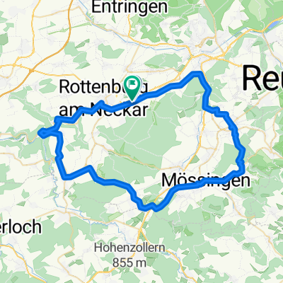
Wurmlingen - Nagold - Herrenberg - Wurmlingen
A cycling route starting in Rottenburg, Baden-Württemberg, Germany.
Overview
About this route
Kleine Rundreise nach Nagold, sehr schön der Blick vom Gäu - Radweg (Nagold Herrenberg) auf den Schönbuch und die Alb
- -:--
- Duration
- 51.1 km
- Distance
- 409 m
- Ascent
- 409 m
- Descent
- ---
- Avg. speed
- ---
- Avg. speed
Route quality
Waytypes & surfaces along the route
Waytypes
Track
20.4 km
(40 %)
Road
12.7 km
(25 %)
Surfaces
Paved
48.6 km
(95 %)
Asphalt
48.3 km
(95 %)
Paving stones
0.3 km
(<1 %)
Undefined
2.5 km
(5 %)
Continue with Bikemap
Use, edit, or download this cycling route
You would like to ride Wurmlingen - Nagold - Herrenberg - Wurmlingen or customize it for your own trip? Here is what you can do with this Bikemap route:
Free features
- Save this route as favorite or in collections
- Copy & plan your own version of this route
- Sync your route with Garmin or Wahoo
Premium features
Free trial for 3 days, or one-time payment. More about Bikemap Premium.
- Navigate this route on iOS & Android
- Export a GPX / KML file of this route
- Create your custom printout (try it for free)
- Download this route for offline navigation
Discover more Premium features.
Get Bikemap PremiumFrom our community
Other popular routes starting in Rottenburg
 Schönbuch - Altdorf
- Distance
- 42.3 km
- Ascent
- 533 m
- Descent
- 533 m
- Location
- Rottenburg, Baden-Württemberg, Germany
 Kiebingen
- Distance
- 61 km
- Ascent
- 395 m
- Descent
- 394 m
- Location
- Rottenburg, Baden-Württemberg, Germany
 Kornbühlrunde
- Distance
- 88.8 km
- Ascent
- 986 m
- Descent
- 958 m
- Location
- Rottenburg, Baden-Württemberg, Germany
 Vogelsang 12, Rottenburg am Neckar nach Vogelsang 12, Rottenburg am Neckar
- Distance
- 21.1 km
- Ascent
- 3 m
- Descent
- 11 m
- Location
- Rottenburg, Baden-Württemberg, Germany
 Schönbuch - Weiler Hütte
- Distance
- 50.2 km
- Ascent
- 385 m
- Descent
- 384 m
- Location
- Rottenburg, Baden-Württemberg, Germany
 Nach Dusslingen und Tübingen
- Distance
- 33.5 km
- Ascent
- 234 m
- Descent
- 234 m
- Location
- Rottenburg, Baden-Württemberg, Germany
 Aiblestraße nach Sinsheimer Straße
- Distance
- 113.1 km
- Ascent
- 974 m
- Descent
- 1,151 m
- Location
- Rottenburg, Baden-Württemberg, Germany
 Unbenannte Route
- Distance
- 65.2 km
- Ascent
- 266 m
- Descent
- 376 m
- Location
- Rottenburg, Baden-Württemberg, Germany
Open it in the app