

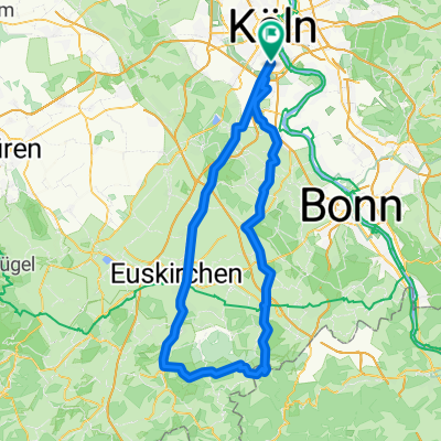
Köln-Dransdorf-Heimerzheim-Brühl-Köln
A cycling route starting in Bayenthal, North Rhine-Westphalia, Germany.
Overview
About this route
From Van Ham via Berzdorf, Falkenlust Castle (80 m tough Paris-Roubaix section) to Dickopshof. From there to Roisdorf (you already know the route) via Alfter along the railway line to Dransdorf. Right turn through Messdorf to Nettekoven from where it’s a steep climb to Buschhoven. Then roll downhill (not so nice in the wind) to Metternich, then right uphill around Rösberg, a short descent (7.5%), then continue to Sechtem. (I might get lost here). Around Brühl to Kalscheuren and from there everything’s under control again. Höningen, Rondorf, finish.
You can also shorten the whole route by about 15 km via Brenig, but the climb there is veeeery nasty. I haven’t managed it yet without stopping, but that doesn’t mean anything.
- -:--
- Duration
- 79.6 km
- Distance
- 252 m
- Ascent
- 252 m
- Descent
- ---
- Avg. speed
- ---
- Max. altitude

Route quality
Waytypes & surfaces along the route
Waytypes
Road
23.1 km
(29 %)
Track
17.5 km
(22 %)
Surfaces
Paved
69.2 km
(87 %)
Unpaved
0.8 km
(1 %)
Asphalt
59.7 km
(75 %)
Paved (undefined)
7.2 km
(9 %)
Continue with Bikemap
Use, edit, or download this cycling route
You would like to ride Köln-Dransdorf-Heimerzheim-Brühl-Köln or customize it for your own trip? Here is what you can do with this Bikemap route:
Free features
- Save this route as favorite or in collections
- Copy & plan your own version of this route
- Sync your route with Garmin or Wahoo
Premium features
Free trial for 3 days, or one-time payment. More about Bikemap Premium.
- Navigate this route on iOS & Android
- Export a GPX / KML file of this route
- Create your custom printout (try it for free)
- Download this route for offline navigation
Discover more Premium features.
Get Bikemap PremiumFrom our community
Other popular routes starting in Bayenthal
 Köln-Ruhrtal und zurück 150 Km
- Distance
- 153.2 km
- Ascent
- 737 m
- Descent
- 724 m
- Location
- Bayenthal, North Rhine-Westphalia, Germany
 Eifeltour
- Distance
- 106.9 km
- Ascent
- 687 m
- Descent
- 639 m
- Location
- Bayenthal, North Rhine-Westphalia, Germany
 So., 28. 07. 2019
- Distance
- 46.1 km
- Ascent
- 59 m
- Descent
- 59 m
- Location
- Bayenthal, North Rhine-Westphalia, Germany
 Um die Dhünntalsperre
- Distance
- 91.9 km
- Ascent
- 884 m
- Descent
- 876 m
- Location
- Bayenthal, North Rhine-Westphalia, Germany
 Kurze Sonntagsrunde am Rhein
- Distance
- 13.7 km
- Ascent
- 91 m
- Descent
- 92 m
- Location
- Bayenthal, North Rhine-Westphalia, Germany
 Köln Südstadt Bergisches Land
- Distance
- 57.9 km
- Ascent
- 372 m
- Descent
- 372 m
- Location
- Bayenthal, North Rhine-Westphalia, Germany
 Hürth- Kalscheuren
- Distance
- 19.9 km
- Ascent
- 51 m
- Descent
- 51 m
- Location
- Bayenthal, North Rhine-Westphalia, Germany
 So., 12. 06. 2022
- Distance
- 48.1 km
- Ascent
- 315 m
- Descent
- 315 m
- Location
- Bayenthal, North Rhine-Westphalia, Germany
Open it in the app