

Walldorf-Amönenhof-Ellenbogen-Wasserkuppe-Schwedenschanze
A cycling route starting in Walldorf, Thuringia, Germany.
Overview
About this route
since the battery no longer lasts, I did not record the ride to Walldorf and then the way back via Bischofsheim, Oberalsbach and Ostheim. the entire route was 153 km long and I overcame 2,800 meters of elevation. In the area of Schafstein, I even had to carry my bike, wrong way, and not only steep, but also with snow, heavy metal
- -:--
- Duration
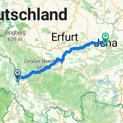
- 70.6 km
- Distance
- 1,716 m
- Ascent
- 1,267 m
- Descent
- ---
- Avg. speed
- ---
- Max. altitude
Continue with Bikemap
Use, edit, or download this cycling route
You would like to ride Walldorf-Amönenhof-Ellenbogen-Wasserkuppe-Schwedenschanze or customize it for your own trip? Here is what you can do with this Bikemap route:
Free features
- Save this route as favorite or in collections
- Copy & plan your own version of this route
- Sync your route with Garmin or Wahoo
Premium features
Free trial for 3 days, or one-time payment. More about Bikemap Premium.
- Navigate this route on iOS & Android
- Export a GPX / KML file of this route
- Create your custom printout (try it for free)
- Download this route for offline navigation
Discover more Premium features.
Get Bikemap PremiumFrom our community
Other popular routes starting in Walldorf
 Sprint
- Distance
- 25.3 km
- Ascent
- 452 m
- Descent
- 452 m
- Location
- Walldorf, Thuringia, Germany
 Leichte Werratal - Radweg-Route
- Distance
- 29.6 km
- Ascent
- 200 m
- Descent
- 156 m
- Location
- Walldorf, Thuringia, Germany
 15.10.14
- Distance
- 56.2 km
- Ascent
- 835 m
- Descent
- 835 m
- Location
- Walldorf, Thuringia, Germany
 Walldorf - Jena
- Distance
- 119.6 km
- Ascent
- 2,043 m
- Descent
- 2,168 m
- Location
- Walldorf, Thuringia, Germany
 Walldorf-Amönenhof-Ellenbogen-Wasserkuppe-Schwedenschanze
- Distance
- 70.6 km
- Ascent
- 1,716 m
- Descent
- 1,267 m
- Location
- Walldorf, Thuringia, Germany
 Wandertag
- Distance
- 37.5 km
- Ascent
- 571 m
- Descent
- 547 m
- Location
- Walldorf, Thuringia, Germany
 Walldorf - Dolmar
- Distance
- 10.4 km
- Ascent
- 558 m
- Descent
- 114 m
- Location
- Walldorf, Thuringia, Germany
 Walldorf - Dolmar
- Distance
- 21.2 km
- Ascent
- 648 m
- Descent
- 643 m
- Location
- Walldorf, Thuringia, Germany
Open it in the app