

Central Reading to "The Vyne" via Roman Silchester
A cycling route starting in Reading, England, United Kingdom.
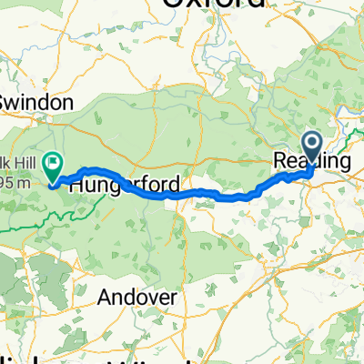
Overview
About this route
The route out of Reading is not the most scenic. Instead of taking the cycle path alongside the A33 Relief Road, some people prefer to take the cycle path along the River Kennet which avoids having traffic a couple of metres to one side and also a few turnings where the cyclist needs to take care of any vehicles turning off. Personally, I find the Kennet cycle path narrow with blind corners and over-hanging trees. Take your pick!
In general, the route follows the Sustrans National Cycle Network (NCN) Route 23, from Reading to Basingstoke, but deviates from it in a few places, such as where the Sustrans route quite unnecessarily insists on taking a muddy track or decides "a little detour would be nice at this point".
- -:--
- Duration
- 29.6 km
- Distance
- 126 m
- Ascent
- 107 m
- Descent
- ---
- Avg. speed
- ---
- Max. altitude

Route quality
Waytypes & surfaces along the route
Waytypes
Road
14.1 km
(48 %)
Quiet road
11.9 km
(40 %)
Surfaces
Paved
29.6 km
(100 %)
Asphalt
29.3 km
(99 %)
Paving stones
0.3 km
(1 %)
Undefined
0 km
(<1 %)
Continue with Bikemap
Use, edit, or download this cycling route
You would like to ride Central Reading to "The Vyne" via Roman Silchester or customize it for your own trip? Here is what you can do with this Bikemap route:
Free features
- Save this route as favorite or in collections
- Copy & plan your own version of this route
- Sync your route with Garmin or Wahoo
Premium features
Free trial for 3 days, or one-time payment. More about Bikemap Premium.
- Navigate this route on iOS & Android
- Export a GPX / KML file of this route
- Create your custom printout (try it for free)
- Download this route for offline navigation
Discover more Premium features.
Get Bikemap PremiumFrom our community
Other popular routes starting in Reading
 Reading to Bristol via Bath
- Distance
- 156.5 km
- Ascent
- 1,062 m
- Descent
- 1,097 m
- Location
- Reading, England, United Kingdom
 27 Newcastle Road, Reading to 25 Newcastle Road, Reading
- Distance
- 36.9 km
- Ascent
- 13 m
- Descent
- 75 m
- Location
- Reading, England, United Kingdom
 Recovered Route
- Distance
- 37.6 km
- Ascent
- 17 m
- Descent
- 57 m
- Location
- Reading, England, United Kingdom
 pierwsza
- Distance
- 23.5 km
- Ascent
- 32 m
- Descent
- 25 m
- Location
- Reading, England, United Kingdom
 Reading Chiltern loop
- Distance
- 68.4 km
- Ascent
- 401 m
- Descent
- 401 m
- Location
- Reading, England, United Kingdom
 Reading to Littlewick Green
- Distance
- 19.1 km
- Ascent
- 155 m
- Descent
- 186 m
- Location
- Reading, England, United Kingdom
 XC loop from Caversham
- Distance
- 40.9 km
- Ascent
- 293 m
- Descent
- 292 m
- Location
- Reading, England, United Kingdom
 From Reading to Marlborough
- Distance
- 76.5 km
- Ascent
- 408 m
- Descent
- 310 m
- Location
- Reading, England, United Kingdom
Open it in the app