


20160404_083358.gpx
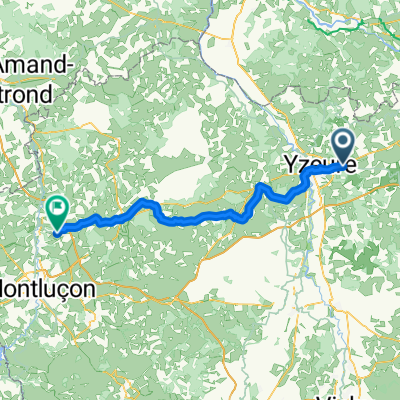
A cycling route starting in Yzeure, Auvergne-Rhône-Alpes, France.
Overview
About this route
0
TEASI track
- -:--
- Duration
- 48 km
- Distance
- 180 m
- Ascent
- 180 m
- Descent
- ---
- Avg. speed
- ---
- Max. altitude
malet
created this 10 years ago
Route quality
Waytypes & surfaces along the route
Waytypes
Road
16.3 km
34 %
Quiet road
3.4 km
7 %
Surfaces
Paved
17.7 km
(37 %)
Unpaved
2.4 km
(5 %)
Asphalt
17.7 km
37 %
Ground
2.4 km
5 %
Undefined
27.8 km
58 %
Continue with Bikemap
Use, edit, or download this cycling route
You would like to ride 20160404_083358.gpx or customize it for your own trip? Here is what you can do with this Bikemap route:
Free features
- Save this route as favorite or in collections
- Copy & plan your own version of this route
- Sync your route with Garmin or Wahoo
Premium features
Free trial for 3 days, or one-time payment. More about Bikemap Premium.
- Navigate this route on iOS & Android
- Export a GPX / KML file of this route
- Create your custom printout (try it for free)
- Download this route for offline navigation
Discover more Premium features.
Get Bikemap PremiumFrom our community
Other popular routes starting in Yzeure

 60 Boulevard Louis Guillot, Yzeure à 60 Boulevard Louis Guillot, Yzeure0
- 60 km
- 271 m
- 271 m
- Yzeure, Auvergne-Rhône-Alpes, France


Open it in the app