

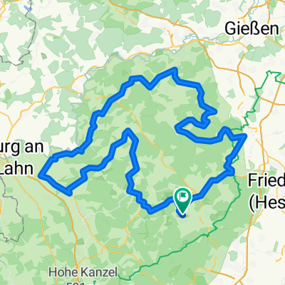
CTF Altweilnau 2016, mittlere Route ca 50 km
A cycling route starting in Neu-Anspach, Hesse, Germany.
Overview
About this route
Crossing and winding through the beautiful Taunus, picturesque route, no technical sections (forest paths, short asphalt/road sections). Some challenging ascents.
- -:--
- Duration
- 49.9 km
- Distance
- 830 m
- Ascent
- 843 m
- Descent
- ---
- Avg. speed
- ---
- Max. altitude

Route quality
Waytypes & surfaces along the route
Waytypes
Track
41.4 km
(83 %)
Quiet road
2.5 km
(5 %)
Surfaces
Paved
9.5 km
(19 %)
Unpaved
36.9 km
(74 %)
Gravel
18 km
(36 %)
Loose gravel
10 km
(20 %)
Continue with Bikemap
Use, edit, or download this cycling route
You would like to ride CTF Altweilnau 2016, mittlere Route ca 50 km or customize it for your own trip? Here is what you can do with this Bikemap route:
Free features
- Save this route as favorite or in collections
- Copy & plan your own version of this route
- Sync your route with Garmin or Wahoo
Premium features
Free trial for 3 days, or one-time payment. More about Bikemap Premium.
- Navigate this route on iOS & Android
- Export a GPX / KML file of this route
- Create your custom printout (try it for free)
- Download this route for offline navigation
Discover more Premium features.
Get Bikemap PremiumFrom our community
Other popular routes starting in Neu-Anspach
 Route Michelbach
- Distance
- 27.2 km
- Ascent
- 356 m
- Descent
- 355 m
- Location
- Neu-Anspach, Hesse, Germany
 RTF-Neu-Anspach Tour 2/150 km
- Distance
- 150.5 km
- Ascent
- 2,295 m
- Descent
- 2,296 m
- Location
- Neu-Anspach, Hesse, Germany
 Nightride Tour
- Distance
- 31 km
- Ascent
- 369 m
- Descent
- 390 m
- Location
- Neu-Anspach, Hesse, Germany
 Taunus Tour 1 - Hahnstätten - Taunusstein
- Distance
- 105.5 km
- Ascent
- 1,363 m
- Descent
- 1,246 m
- Location
- Neu-Anspach, Hesse, Germany
 CTF Altweilnau 2016, mittlere Route ca 50 km
- Distance
- 49.9 km
- Ascent
- 830 m
- Descent
- 843 m
- Location
- Neu-Anspach, Hesse, Germany
 Weilnauer Straße, Weilrod nach Weilnauer Straße, Weilrod
- Distance
- 48.2 km
- Ascent
- 934 m
- Descent
- 934 m
- Location
- Neu-Anspach, Hesse, Germany
 NeuAnspach-Wetterau-Frankfurt
- Distance
- 64.9 km
- Ascent
- 466 m
- Descent
- 697 m
- Location
- Neu-Anspach, Hesse, Germany
 Erste Fahrt alleine mit dem neuen Bike
- Distance
- 31.7 km
- Ascent
- 433 m
- Descent
- 437 m
- Location
- Neu-Anspach, Hesse, Germany
Open it in the app