

Overview
About this route
-
-
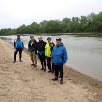
- Věra, Roman, Mirek, Pavlík, Ivan, Matthew.
-
- -:--
- Duration
- 64.2 km
- Distance
- 240 m
- Ascent
- 369 m
- Descent
- ---
- Avg. speed
- ---
- Max. altitude

Part of
2016_04 Horní Uhry
5 stages
Route quality
Waytypes & surfaces along the route
Waytypes
Busy road
35.8 km
(56 %)
Road
14.7 km
(23 %)
Surfaces
Paved
35.4 km
(55 %)
Unpaved
2.1 km
(3 %)
Asphalt
34.4 km
(54 %)
Unpaved (undefined)
2 km
(3 %)
Continue with Bikemap
Use, edit, or download this cycling route
You would like to ride Stakčín_Užhorod or customize it for your own trip? Here is what you can do with this Bikemap route:
Free features
- Save this route as favorite or in collections
- Copy & plan your own version of this route
- Sync your route with Garmin or Wahoo
Premium features
Free trial for 3 days, or one-time payment. More about Bikemap Premium.
- Navigate this route on iOS & Android
- Export a GPX / KML file of this route
- Create your custom printout (try it for free)
- Download this route for offline navigation
Discover more Premium features.
Get Bikemap PremiumFrom our community
Other popular routes starting in Snina
 Ruské sedlo
- Distance
- 15.1 km
- Ascent
- 548 m
- Descent
- 232 m
- Location
- Snina, Prešov Region, Slovakia
 Ruská Volová - Medová baba
- Distance
- 34.9 km
- Ascent
- 865 m
- Descent
- 465 m
- Location
- Snina, Prešov Region, Slovakia
 Snina - Zemplínske Hámre - rybníky
- Distance
- 16.6 km
- Ascent
- 341 m
- Descent
- 340 m
- Location
- Snina, Prešov Region, Slovakia
 Polianka, Medzilaborce, Svidník, Stropkov, Domaša, Humenné, Polianka
- Distance
- 217.9 km
- Ascent
- 2,008 m
- Descent
- 2,009 m
- Location
- Snina, Prešov Region, Slovakia
 Poloniny Nemzeti park.
- Distance
- 103 km
- Ascent
- 956 m
- Descent
- 956 m
- Location
- Snina, Prešov Region, Slovakia
 Stakčín-Starina-Ulič-Holica-Ruská Volová-Snina
- Distance
- 40.9 km
- Ascent
- 662 m
- Descent
- 661 m
- Location
- Snina, Prešov Region, Slovakia
 Snina- Dlhé n. Cir.- Kamenica n.Cir.- Humenné
- Distance
- 21.6 km
- Ascent
- 48 m
- Descent
- 112 m
- Location
- Snina, Prešov Region, Slovakia
 Snina-rybníky- Konské -okolo Mors. Oka
- Distance
- 69.6 km
- Ascent
- 1,433 m
- Descent
- 1,431 m
- Location
- Snina, Prešov Region, Slovakia
Open it in the app