

Füzér_Nagy Milic_Košice
A cycling route starting in Gönc, Borsod-Abauj Zemplen county, Hungary.
Overview
About this route
-
-
- Na Nagy Milic pěšky Věra, Mirek, Ivan, Pavlík, Roman.
-
Pak do Košic Matthew, Věra, Mirek, Ivan, Pavlík, Roman.
- -:--
- Duration
- 51.8 km
- Distance
- 742 m
- Ascent
- 906 m
- Descent
- ---
- Avg. speed
- ---
- Avg. speed

Route quality
Waytypes & surfaces along the route
Waytypes
Road
18 km
(35 %)
Quiet road
8.2 km
(16 %)
Surfaces
Paved
22.6 km
(44 %)
Unpaved
6 km
(12 %)
Asphalt
19.5 km
(38 %)
Ground
4.2 km
(8 %)
Continue with Bikemap
Use, edit, or download this cycling route
You would like to ride Füzér_Nagy Milic_Košice or customize it for your own trip? Here is what you can do with this Bikemap route:
Free features
- Save this route as favorite or in collections
- Copy & plan your own version of this route
- Sync your route with Garmin or Wahoo
Premium features
Free trial for 3 days, or one-time payment. More about Bikemap Premium.
- Navigate this route on iOS & Android
- Export a GPX / KML file of this route
- Create your custom printout (try it for free)
- Download this route for offline navigation
Discover more Premium features.
Get Bikemap PremiumFrom our community
Other popular routes starting in Gönc
 Zemplén 2014.
- Distance
- 70.8 km
- Ascent
- 1,338 m
- Descent
- 1,338 m
- Location
- Gönc, Borsod-Abauj Zemplen county, Hungary
 Telkibánya 38 km-es kör
- Distance
- 37.8 km
- Ascent
- 559 m
- Descent
- 559 m
- Location
- Gönc, Borsod-Abauj Zemplen county, Hungary
 Telkibánya, Sólyom-kő, Amadé-vár rom, Hejcei emlékpark kör
- Distance
- 31.4 km
- Ascent
- 864 m
- Descent
- 865 m
- Location
- Gönc, Borsod-Abauj Zemplen county, Hungary
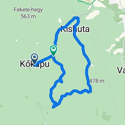 Kőkapu-Kishuta-Nagyhuta (kör)
- Distance
- 19.4 km
- Ascent
- 433 m
- Descent
- 458 m
- Location
- Gönc, Borsod-Abauj Zemplen county, Hungary
 Múzeum út 8a., Telkibánya to Múzeum út 11., Telkibánya
- Distance
- 37.7 km
- Ascent
- 970 m
- Descent
- 980 m
- Location
- Gönc, Borsod-Abauj Zemplen county, Hungary
 Kőkapu 2
- Distance
- 13 km
- Ascent
- 434 m
- Descent
- 433 m
- Location
- Gönc, Borsod-Abauj Zemplen county, Hungary
 STEREO 10.3 Kőkapu - Ördög völgy - Gerendás Rétig
- Distance
- 10.3 km
- Ascent
- 351 m
- Descent
- 146 m
- Location
- Gönc, Borsod-Abauj Zemplen county, Hungary
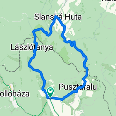 Füzér, Izra-tó, Szalánchuta, Lászlótanya kör
- Distance
- 22.5 km
- Ascent
- 636 m
- Descent
- 636 m
- Location
- Gönc, Borsod-Abauj Zemplen county, Hungary
Open it in the app