

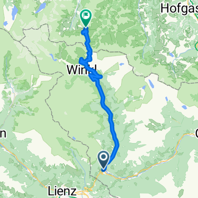
Winklern-Glockner-Hochtor
A cycling route starting in Winklern, Carinthia, Austria.
Overview
About this route
Winklern-Heiligenblut-Hochtor-Edelweissspitze-return
- -:--
- Duration
- 89.1 km
- Distance
- 2,012 m
- Ascent
- 2,012 m
- Descent
- ---
- Avg. speed
- ---
- Max. altitude

Route quality
Waytypes & surfaces along the route
Waytypes
Road
43.7 km
(49 %)
Track
16 km
(18 %)
Surfaces
Paved
72.2 km
(81 %)
Unpaved
7.1 km
(8 %)
Asphalt
67.7 km
(76 %)
Gravel
7.1 km
(8 %)
Continue with Bikemap
Use, edit, or download this cycling route
You would like to ride Winklern-Glockner-Hochtor or customize it for your own trip? Here is what you can do with this Bikemap route:
Free features
- Save this route as favorite or in collections
- Copy & plan your own version of this route
- Split it into stages to create a multi-day tour
- Sync your route with Garmin or Wahoo
Premium features
Free trial for 3 days, or one-time payment. More about Bikemap Premium.
- Navigate this route on iOS & Android
- Export a GPX / KML file of this route
- Create your custom printout (try it for free)
- Download this route for offline navigation
Discover more Premium features.
Get Bikemap PremiumFrom our community
Other popular routes starting in Winklern
 RR-Berg: Grossglockner KURZ (Winklern-Heiligenblut-Hochtor-Edelweissspitze)
- Distance
- 45.3 km
- Ascent
- 1,992 m
- Descent
- 370 m
- Location
- Winklern, Carinthia, Austria
 Itálie 1999 - 4. etapa (1.8.1999)
- Distance
- 132.5 km
- Ascent
- 1,298 m
- Descent
- 2,302 m
- Location
- Winklern, Carinthia, Austria
 Großglockner
- Distance
- 90.3 km
- Ascent
- 2,197 m
- Descent
- 2,197 m
- Location
- Winklern, Carinthia, Austria
 3 - Winklern - Heiligenblut
- Distance
- 25 km
- Ascent
- 607 m
- Descent
- 190 m
- Location
- Winklern, Carinthia, Austria
 Lienz - Stallersattel - Jaufenpass - Stilfser Joch - Bormio
- Distance
- 315.7 km
- Ascent
- 5,760 m
- Descent
- 5,490 m
- Location
- Winklern, Carinthia, Austria
 Mi10 Winklern - Heiligenblut 22+22 330HM
- Distance
- 21.6 km
- Ascent
- 566 m
- Descent
- 149 m
- Location
- Winklern, Carinthia, Austria
 Großglocknertour 2008 - Tag 2
- Distance
- 74 km
- Ascent
- 2,408 m
- Descent
- 2,575 m
- Location
- Winklern, Carinthia, Austria
 Itálie 1999 - 4. etapa (1.8.1999) CLONED FROM ROUTE 304686
- Distance
- 128.6 km
- Ascent
- 1,248 m
- Descent
- 2,270 m
- Location
- Winklern, Carinthia, Austria
Open it in the app