

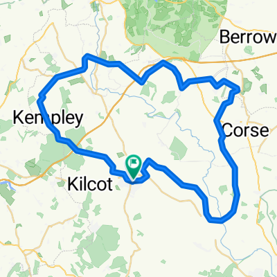
Pendock TT
A cycling route starting in Newent, England, United Kingdom.
Overview
About this route
- -:--
- Duration
- 15.3 km
- Distance
- 70 m
- Ascent
- 73 m
- Descent
- ---
- Avg. speed
- ---
- Max. altitude
Route quality
Waytypes & surfaces along the route
Waytypes
Cycleway
4.3 km
(28 %)
Road
2.8 km
(18 %)
Surfaces
Paved
0.5 km
(3 %)
Asphalt
0.5 km
(3 %)
Undefined
14.8 km
(97 %)
Continue with Bikemap
Use, edit, or download this cycling route
You would like to ride Pendock TT or customize it for your own trip? Here is what you can do with this Bikemap route:
Free features
- Save this route as favorite or in collections
- Copy & plan your own version of this route
- Sync your route with Garmin or Wahoo
Premium features
Free trial for 3 days, or one-time payment. More about Bikemap Premium.
- Navigate this route on iOS & Android
- Export a GPX / KML file of this route
- Create your custom printout (try it for free)
- Download this route for offline navigation
Discover more Premium features.
Get Bikemap PremiumFrom our community
Other popular routes starting in Newent
 Newent loop on NCL - longer
- Distance
- 43.6 km
- Ascent
- 242 m
- Descent
- 241 m
- Location
- Newent, England, United Kingdom
 Recovered Route
- Distance
- 0.6 km
- Ascent
- 10 m
- Descent
- 0 m
- Location
- Newent, England, United Kingdom
 Newent, Highleadon, Upleadon Loop
- Distance
- 20.5 km
- Ascent
- 105 m
- Descent
- 106 m
- Location
- Newent, England, United Kingdom
 354 Foley Road, Newent to 350 Foley Road, Newent
- Distance
- 49.3 km
- Ascent
- 124 m
- Descent
- 124 m
- Location
- Newent, England, United Kingdom
 Recovered Route
- Distance
- 9.9 km
- Ascent
- 140 m
- Descent
- 144 m
- Location
- Newent, England, United Kingdom
 The Library to Church Street 2
- Distance
- 99.2 km
- Ascent
- 1,340 m
- Descent
- 1,336 m
- Location
- Newent, England, United Kingdom
 2 Gloucester St, Newent to B4332, Boncath
- Distance
- 203.5 km
- Ascent
- 2,764 m
- Descent
- 2,645 m
- Location
- Newent, England, United Kingdom
 Pendock TT
- Distance
- 15.3 km
- Ascent
- 70 m
- Descent
- 73 m
- Location
- Newent, England, United Kingdom
Open it in the app