

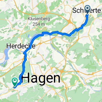
Ergste Rundfahrt 32km 0516
A cycling route starting in Schwerte, North Rhine-Westphalia, Germany.
Overview
About this route
Ergste tour 200m elevation with restaurant, 32 km
- -:--
- Duration
- 33.6 km
- Distance
- 211 m
- Ascent
- 210 m
- Descent
- ---
- Avg. speed
- ---
- Max. altitude

Route quality
Waytypes & surfaces along the route
Waytypes
Road
10.4 km
(31 %)
Quiet road
9.7 km
(29 %)
Surfaces
Paved
20.8 km
(62 %)
Unpaved
2.3 km
(7 %)
Asphalt
20.1 km
(60 %)
Gravel
2 km
(6 %)
Continue with Bikemap
Use, edit, or download this cycling route
You would like to ride Ergste Rundfahrt 32km 0516 or customize it for your own trip? Here is what you can do with this Bikemap route:
Free features
- Save this route as favorite or in collections
- Copy & plan your own version of this route
- Sync your route with Garmin or Wahoo
Premium features
Free trial for 3 days, or one-time payment. More about Bikemap Premium.
- Navigate this route on iOS & Android
- Export a GPX / KML file of this route
- Create your custom printout (try it for free)
- Download this route for offline navigation
Discover more Premium features.
Get Bikemap PremiumFrom our community
Other popular routes starting in Schwerte
 Route Aplerbeck-Rheinischer Esel
- Distance
- 30.5 km
- Ascent
- 291 m
- Descent
- 290 m
- Location
- Schwerte, North Rhine-Westphalia, Germany
 RTF RRC Dortmund 08 2008 118 km
- Distance
- 107.4 km
- Ascent
- 1,286 m
- Descent
- 1,198 m
- Location
- Schwerte, North Rhine-Westphalia, Germany
 Burgruine Hardenstein (Ruhr)
- Distance
- 59.2 km
- Ascent
- 174 m
- Descent
- 231 m
- Location
- Schwerte, North Rhine-Westphalia, Germany
 Ergste Rundfahrt 32km 0516
- Distance
- 33.6 km
- Ascent
- 211 m
- Descent
- 210 m
- Location
- Schwerte, North Rhine-Westphalia, Germany
 Grabenstraße, Schwerte nach Obermarkt, Hattingen
- Distance
- 47.7 km
- Ascent
- 400 m
- Descent
- 425 m
- Location
- Schwerte, North Rhine-Westphalia, Germany
 Fröndenberg/Ruhr - Schwerte Kanoclub
- Distance
- 25.9 km
- Ascent
- 159 m
- Descent
- 176 m
- Location
- Schwerte, North Rhine-Westphalia, Germany
 Kölner Straße, Hagen nach Kampstraße, Schwerte
- Distance
- 20.3 km
- Ascent
- 216 m
- Descent
- 207 m
- Location
- Schwerte, North Rhine-Westphalia, Germany
 ClaudiMöhnesee
- Distance
- 49 km
- Ascent
- 238 m
- Descent
- 124 m
- Location
- Schwerte, North Rhine-Westphalia, Germany
Open it in the app