

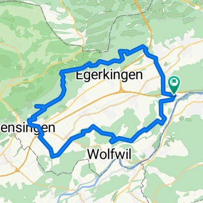
Gunzger Allmend Sumiswald Gettnau
A cycling route starting in Gunzgen, Canton of Solothurn, Switzerland.
Overview
About this route
- -:--
- Duration
- 108.7 km
- Distance
- 714 m
- Ascent
- 709 m
- Descent
- ---
- Avg. speed
- ---
- Max. altitude
Route quality
Waytypes & surfaces along the route
Waytypes
Quiet road
31.9 km
(29 %)
Busy road
26.4 km
(24 %)
Surfaces
Paved
52.3 km
(48 %)
Unpaved
6.3 km
(6 %)
Asphalt
48.2 km
(44 %)
Gravel
6.3 km
(6 %)
Continue with Bikemap
Use, edit, or download this cycling route
You would like to ride Gunzger Allmend Sumiswald Gettnau or customize it for your own trip? Here is what you can do with this Bikemap route:
Free features
- Save this route as favorite or in collections
- Copy & plan your own version of this route
- Split it into stages to create a multi-day tour
- Sync your route with Garmin or Wahoo
Premium features
Free trial for 3 days, or one-time payment. More about Bikemap Premium.
- Navigate this route on iOS & Android
- Export a GPX / KML file of this route
- Create your custom printout (try it for free)
- Download this route for offline navigation
Discover more Premium features.
Get Bikemap PremiumFrom our community
Other popular routes starting in Gunzgen
 Vordere Jurakette
- Distance
- 38.4 km
- Ascent
- 743 m
- Descent
- 743 m
- Location
- Gunzgen, Canton of Solothurn, Switzerland
 Gunzger Allmend Sumiswald Gettnau
- Distance
- 108.7 km
- Ascent
- 714 m
- Descent
- 709 m
- Location
- Gunzgen, Canton of Solothurn, Switzerland
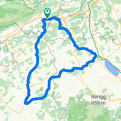
 Born-Rumpel-Belchenhöhe
- Distance
- 36 km
- Ascent
- 1,012 m
- Descent
- 1,012 m
- Location
- Gunzgen, Canton of Solothurn, Switzerland
 Härkingen-Herznach
- Distance
- 33.8 km
- Ascent
- 258 m
- Descent
- 270 m
- Location
- Gunzgen, Canton of Solothurn, Switzerland
 Engelberg-Froburg-General Wille Haus
- Distance
- 40.5 km
- Ascent
- 1,028 m
- Descent
- 1,028 m
- Location
- Gunzgen, Canton of Solothurn, Switzerland
 Jura Derby
- Distance
- 134.7 km
- Ascent
- 1,610 m
- Descent
- 1,610 m
- Location
- Gunzgen, Canton of Solothurn, Switzerland
 Entspannende Route in Derendingen
- Distance
- 27.9 km
- Ascent
- 192 m
- Descent
- 172 m
- Location
- Gunzgen, Canton of Solothurn, Switzerland
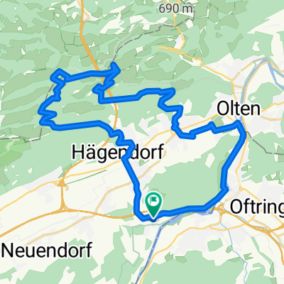 Olten-Wangen-Rumpel-Spitelberg-Belchenfluh- Hägendorf- Boningen
- Distance
- 35.1 km
- Ascent
- 777 m
- Descent
- 777 m
- Location
- Gunzgen, Canton of Solothurn, Switzerland
Open it in the app