

Girl Scouts Biking Adventure
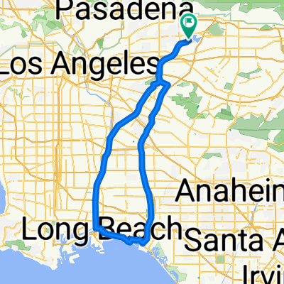
A cycling route starting in North El Monte, California, United States.
Overview
About this route
From: Peck Rd. Water Conservation Park, 5401 Peck Rd, Arcadia, CA 91006
To: Sante Fe Dam 15501 Arrow Hwy, Irwindale, CA 91706
- -:--
- Duration
- 33.1 km
- Distance
- 125 m
- Ascent
- 80 m
- Descent
- ---
- Avg. speed
- ---
- Max. altitude
Route quality
Waytypes & surfaces along the route
Waytypes
Cycleway
31.6 km
(95 %)
Quiet road
0.9 km
(3 %)
Pedestrian area
0.7 km
(2 %)
Surfaces
Paved
21 km
(63 %)
Asphalt
9.6 km
(29 %)
Paved (undefined)
6.3 km
(19 %)
Route highlights
Points of interest along the route
Point of interest after 9.8 km
Meet up with group that wants to do the shorter route
Point of interest after 12.1 km
Cross the street/ Walk the Bike
Point of interest after 26.7 km
Cross the street/ Walk the bike
Point of interest after 27.2 km
Small uphill portion to the Dam. I will give some prizes to those who can get to the top without walking the bike!
Point of interest after 27.7 km
Regroup after the small hill to ride together to the finish
Continue with Bikemap
Use, edit, or download this cycling route
You would like to ride Girl Scouts Biking Adventure or customize it for your own trip? Here is what you can do with this Bikemap route:
Free features
- Save this route as favorite or in collections
- Copy & plan your own version of this route
- Sync your route with Garmin or Wahoo
Premium features
Free trial for 3 days, or one-time payment. More about Bikemap Premium.
- Navigate this route on iOS & Android
- Export a GPX / KML file of this route
- Create your custom printout (try it for free)
- Download this route for offline navigation
Discover more Premium features.
Get Bikemap PremiumFrom our community
Other popular routes starting in North El Monte
 Girl Scouts Biking Adventure
- Distance
- 31.9 km
- Ascent
- 106 m
- Descent
- 62 m
- Location
- North El Monte, California, United States
 Embree Drive 11521, El Monte to Río Hondo Bike Path, South El Monte
- Distance
- 7.5 km
- Ascent
- 2 m
- Descent
- 4 m
- Location
- North El Monte, California, United States
 Broken bike ride, Sept 3, 2015
- Distance
- 14.9 km
- Ascent
- 104 m
- Descent
- 28 m
- Location
- North El Monte, California, United States
 Rio Hondo
- Distance
- 102.7 km
- Ascent
- 137 m
- Descent
- 133 m
- Location
- North El Monte, California, United States
 El Monte Airport Breakfast Ride
- Distance
- 30 km
- Ascent
- 59 m
- Descent
- 62 m
- Location
- North El Monte, California, United States
 Rio Hondo/Azusa Roundup
- Distance
- 154 km
- Ascent
- 267 m
- Descent
- 267 m
- Location
- North El Monte, California, United States
 Celine Street 11555, El Monte to Rancho Cam Drive 13521, Paramount
- Distance
- 29 km
- Ascent
- 342 m
- Descent
- 414 m
- Location
- North El Monte, California, United States
 4500 Riverview Ave, El Monte to 228 W Pomona Ave, Monrovia
- Distance
- 7.3 km
- Ascent
- 80 m
- Descent
- 35 m
- Location
- North El Monte, California, United States
Open it in the app