Dillstädt-Simmersberg-Werraquelle-Oelze-Kahlert-St. Kilian (Teil 2)
A cycling route starting in Neustadt am Rennsteig, Thuringia, Germany.
Overview
About this route
from Kahlert I went down the Tannengrund to the Schönbrunn dam-then back up the other side-this is now a wide gravel path and marked as an MTB trail-at the top you find yourself at the lower end of Frauenwald-right back down the Frauenwalder Straße (forest path) into Schleusingerneundorf-to avoid taking the cycle path (so boring), I immediately went back up at the end of the village to Silbach-there is where the world ends-there's only one road to Hinternah-that was it-another few meters back up and you stand above Breitenbach in Vessertal-down there it goes radically on asphalt-until the cycle path to St. Kilian then goes very fast.
- -:--
- Duration
- 27.8 km
- Distance
- 448 m
- Ascent
- 813 m
- Descent
- ---
- Avg. speed
- ---
- Max. altitude
Route quality
Waytypes & surfaces along the route
Waytypes
Track
19.7 km
(71 %)
Access road
2.5 km
(9 %)
Surfaces
Paved
11.1 km
(40 %)
Unpaved
13.9 km
(50 %)
Gravel
12.8 km
(46 %)
Asphalt
10.6 km
(38 %)
Continue with Bikemap
Use, edit, or download this cycling route
You would like to ride Dillstädt-Simmersberg-Werraquelle-Oelze-Kahlert-St. Kilian (Teil 2) or customize it for your own trip? Here is what you can do with this Bikemap route:
Free features
- Save this route as favorite or in collections
- Copy & plan your own version of this route
- Sync your route with Garmin or Wahoo
Premium features
Free trial for 3 days, or one-time payment. More about Bikemap Premium.
- Navigate this route on iOS & Android
- Export a GPX / KML file of this route
- Create your custom printout (try it for free)
- Download this route for offline navigation
Discover more Premium features.
Get Bikemap PremiumFrom our community
Other popular routes starting in Neustadt am Rennsteig
- Dillstädt-Simmersberg-Werraquelle-Oelze-Kahlert-St. Kilian (Teil 2)
- Distance
- 27.8 km
- Ascent
- 448 m
- Descent
- 813 m
- Location
- Neustadt am Rennsteig, Thuringia, Germany
- Etappe5
- Distance
- 117.6 km
- Ascent
- 2,060 m
- Descent
- 2,636 m
- Location
- Neustadt am Rennsteig, Thuringia, Germany
- Etappe 5 Neustadt Volkach
- Distance
- 116.4 km
- Ascent
- 772 m
- Descent
- 1,342 m
- Location
- Neustadt am Rennsteig, Thuringia, Germany
- Rennsteig von Neustadt nach Neuhaus u. zurück
- Distance
- 61.5 km
- Ascent
- 772 m
- Descent
- 772 m
- Location
- Neustadt am Rennsteig, Thuringia, Germany
- Hüttenstraße 49, Großbreitenbach nach Hüttenstraße 49, Großbreitenbach
- Distance
- 12.1 km
- Ascent
- 240 m
- Descent
- 218 m
- Location
- Neustadt am Rennsteig, Thuringia, Germany
- Rennsteigstraße 44, Großbreitenbach nach Bahndamm 4, Ilmenau
- Distance
- 26.4 km
- Ascent
- 168 m
- Descent
- 475 m
- Location
- Neustadt am Rennsteig, Thuringia, Germany
- Rennsteig Tag 3
- Distance
- 56.7 km
- Ascent
- 476 m
- Descent
- 632 m
- Location
- Neustadt am Rennsteig, Thuringia, Germany
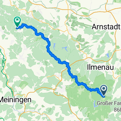
- Talsperre Schönbrunn Variante über Frauenwald II
- Distance
- 25.7 km
- Ascent
- 539 m
- Descent
- 540 m
- Location
- Neustadt am Rennsteig, Thuringia, Germany
Open it in the app