

Steiermark 3 - Südliche Mur
A cycling route starting in Unterpremstätten, Styria, Austria.
Overview
About this route
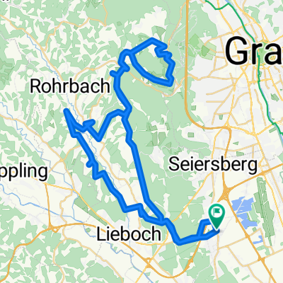
Unterpremstätten-Wagnitz-Karlsdorf-Kleinsulz-Großsulz-Werndorf-Wildon-Kaindorf-Leibnitz-along the Sulm and the Laßnitz-Tillmitsch-Lang-Jöß-Schönberg-Lichendorf-Weitendorf-Ponigl-Wundschuh-Forst-Kasten-Gradenfeld-Bierbaum-Unterpremstätten
- -:--
- Duration
- 76.7 km
- Distance
- 172 m
- Ascent
- 176 m
- Descent
- ---
- Avg. speed
- ---
- Max. altitude

Route quality
Waytypes & surfaces along the route
Waytypes
Quiet road
32.2 km
(42 %)
Cycleway
12.3 km
(16 %)
Surfaces
Paved
56.8 km
(74 %)
Unpaved
3.8 km
(5 %)
Asphalt
56 km
(73 %)
Gravel
3.1 km
(4 %)
Route highlights
Points of interest along the route
Point of interest after 0 km
Urdlwirt Unterpremstätten
Point of interest after 27.5 km
Kaffeepause am Strandbad
Point of interest after 43.5 km
Pause mit Temmel-Eis
Point of interest after 60.6 km
Vesper-Pause im Buschenschank
Continue with Bikemap
Use, edit, or download this cycling route
You would like to ride Steiermark 3 - Südliche Mur or customize it for your own trip? Here is what you can do with this Bikemap route:
Free features
- Save this route as favorite or in collections
- Copy & plan your own version of this route
- Sync your route with Garmin or Wahoo
Premium features
Free trial for 3 days, or one-time payment. More about Bikemap Premium.
- Navigate this route on iOS & Android
- Export a GPX / KML file of this route
- Create your custom printout (try it for free)
- Download this route for offline navigation
Discover more Premium features.
Get Bikemap PremiumFrom our community
Other popular routes starting in Unterpremstätten
 Steiermark 3 - Südliche Mur
- Distance
- 76.7 km
- Ascent
- 172 m
- Descent
- 176 m
- Location
- Unterpremstätten, Styria, Austria
 Über die süd-westl Hügeln
- Distance
- 54 km
- Ascent
- 564 m
- Descent
- 564 m
- Location
- Unterpremstätten, Styria, Austria
 UP-Feldkirchen-Graz-Thal/Eben-Steinberg-Hitzendorf-Doblegg-Tobelbad-Dobl-Zwaring-Wundschuh-SFZ
- Distance
- 64.8 km
- Ascent
- 420 m
- Descent
- 438 m
- Location
- Unterpremstätten, Styria, Austria
 Steiermark 2 - Westl. Steiermark
- Distance
- 56.4 km
- Ascent
- 535 m
- Descent
- 535 m
- Location
- Unterpremstätten, Styria, Austria
 Die Südrunde
- Distance
- 55.7 km
- Ascent
- 159 m
- Descent
- 159 m
- Location
- Unterpremstätten, Styria, Austria
 Schwarzlsee - Wildon - Kirchberg - St. Margarethen - Nestelbach - Schwarzlsee
- Distance
- 88.4 km
- Ascent
- 946 m
- Descent
- 953 m
- Location
- Unterpremstätten, Styria, Austria
 Glocknerman 2014
- Distance
- 1,054.8 km
- Ascent
- 7,201 m
- Descent
- 7,201 m
- Location
- Unterpremstätten, Styria, Austria
 Südsteiermark
- Distance
- 90.1 km
- Ascent
- 528 m
- Descent
- 636 m
- Location
- Unterpremstätten, Styria, Austria
Open it in the app