
24 h challenge
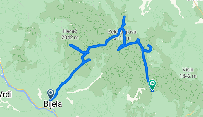
A cycling route starting in Potoci, Federation of Bosnia and Herzegovina, Bosnia and Herzegovina.
Overview
About this route
jezusmarija
- -:--
- Duration
- 36.1 km
- Distance
- 3,558 m
- Ascent
- 2,275 m
- Descent
- ---
- Avg. speed
- ---
- Max. altitude

Route highlights
Points of interest along the route
Accommodation after 6.6 km
NOVI KONTEJNER
Point of interest after 6.7 km
OVČA
Point of interest after 11 km
HERAČ
Point of interest after 11.8 km
VIDINA KAPA
Point of interest after 13.4 km
LUPOGLAV
Point of interest after 14.5 km
VJETRENA BRDA -ERAČ
Point of interest after 20.4 km
VELIKA KAPA
Point of interest after 23.3 km
OTIŠ
Point of interest after 23.7 km
ZELENA GLAVA
Point of interest after 24.4 km
BOTINI
Accommodation after 27.2 km
JEZERCE
Point of interest after 30.1 km
V. OSOBAC
Point of interest after 36.1 km
BIJELE VODE
Continue with Bikemap
Use, edit, or download this cycling route
You would like to ride 24 h challenge or customize it for your own trip? Here is what you can do with this Bikemap route:
Free features
- Save this route as favorite or in collections
- Copy & plan your own version of this route
- Sync your route with Garmin or Wahoo
Premium features
Free trial for 3 days, or one-time payment. More about Bikemap Premium.
- Navigate this route on iOS & Android
- Export a GPX / KML file of this route
- Create your custom printout (try it for free)
- Download this route for offline navigation
Discover more Premium features.
Get Bikemap PremiumFrom our community
Other popular routes starting in Potoci
 24 h challenge
- Distance
- 36.1 km
- Ascent
- 3,558 m
- Descent
- 2,275 m
- Location
- Potoci, Federation of Bosnia and Herzegovina, Bosnia and Herzegovina
 Raška gora
- Distance
- 64.9 km
- Ascent
- 1,360 m
- Descent
- 1,360 m
- Location
- Potoci, Federation of Bosnia and Herzegovina, Bosnia and Herzegovina
 RUTA, Potoci, Rošca, Rujište, Potoci
- Distance
- 34.4 km
- Ascent
- 1,247 m
- Descent
- 1,247 m
- Location
- Potoci, Federation of Bosnia and Herzegovina, Bosnia and Herzegovina

Garmin
Humulisani Loop : by Špinavá Parta- Distance
- 34.7 km
- Ascent
- 690 m
- Descent
- 692 m
- Location
- Potoci, Federation of Bosnia and Herzegovina, Bosnia and Herzegovina
 Semetovac - Jasenjani
- Distance
- 24.6 km
- Ascent
- 1,127 m
- Descent
- 181 m
- Location
- Potoci, Federation of Bosnia and Herzegovina, Bosnia and Herzegovina
 RUTA, Semetovac-Put za rosca
- Distance
- 24.6 km
- Ascent
- 548 m
- Descent
- 548 m
- Location
- Potoci, Federation of Bosnia and Herzegovina, Bosnia and Herzegovina
 RUTA, Kuti - Grabovica
- Distance
- 32.3 km
- Ascent
- 372 m
- Descent
- 381 m
- Location
- Potoci, Federation of Bosnia and Herzegovina, Bosnia and Herzegovina
 raska goraa
- Distance
- 7.6 km
- Ascent
- 453 m
- Descent
- 73 m
- Location
- Potoci, Federation of Bosnia and Herzegovina, Bosnia and Herzegovina
Open it in the app