


alpthal-rothenturm-einsiedeln
- 32.8 km
- 612 m
- 612 m
- Einsiedeln, Canton of Schwyz, Switzerland
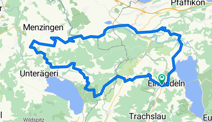
A cycling route starting in Einsiedeln, Canton of Schwyz, Switzerland.
Overview
We leave Einsiedeln heading west, passing the Rosengarten brewery and the hospital, towards Katzenstrick. On the steep climb, it's worth looking back, as there is a beautiful view of Einsiedeln. At the height of Katzenstrick (1053 m), the asphalt road temporarily turns into a natural surface road. We descend swiftly to the third Altmatt, where we briefly turn left onto the busy cantonal road but immediately leave it again to the right. The route crosses the railway line and then leads through the Rothenthurm Moor, temporarily back on a natural road, then asphalt again, ascending towards Morgarten. However, we do not descend all the way to Lake Ägerisee and instead roughly maintain elevation following the road towards Alosen. In Alosen, we cross the main road and continue towards Oberägeri. In the district of Grund, we make a sharp right turn, starting another climb towards the Kisten Pass. Shortly thereafter, we reach the former guided missile site Menzingen-Gubel, now serving as a federal asylum center. We turn left and roll towards the Gubel monastery, which offers a beautiful view over the Zugerland and the neighboring Freiamt. The ride continues via Finstersee, where we temporarily join the main road, descending to the Sihl river. Immediately after the bridge over the Sihl, we turn right and follow the Sihl river upstream for several kilometers on a natural road. Shortly after the road turns back to asphalt, a short but steep climb begins to Hütten. We continue on the main road into the center of Schindellegi. Here, we follow the sign for 'Etzel' on a little-known, temporarily steep but fully asphalted road, reaching again the level of the Sihl at the Devil's Bridge (Teufelsbrücke). Just before it, we pass the birthplace of the famous healer Paracelsus, now the Krone restaurant. One last climb takes us to Roblosen, where the view opens onto Lake Sihlsee. Via Etzelstrasse, we reach Einsiedeln from the north.
created this 9 years ago
Route quality
Quiet road
27 km
(56 %)
Road
12.1 km
(25 %)
Paved
27 km
(56 %)
Unpaved
5.3 km
(11 %)
Asphalt
25.1 km
(52 %)
Gravel
5.3 km
(11 %)
Continue with Bikemap
You would like to ride Rund um den Gottschalkenberg or customize it for your own trip? Here is what you can do with this Bikemap route:
Free trial for 3 days, or one-time payment. More about Bikemap Premium.
Discover more Premium features.
Get Bikemap PremiumFrom our community
Open it in the app


