

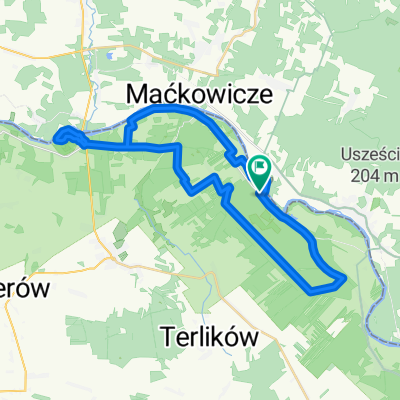
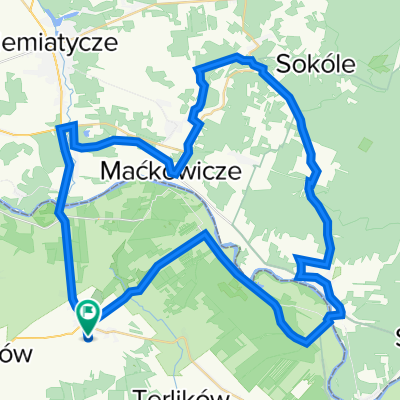
Overview
About this route
Mielnik - Koterka (Orthodox church) - Tokary (church) - Zubacze (Orthodox church) - Klukowicze LUNCH at the shop - Czeremcha - Repczyce (bath) - Dobrowoda (wine) - Dubicze Cerkiewne
- -:--
- Duration
- 60.4 km
- Distance
- 176 m
- Ascent
- 138 m
- Descent
- ---
- Avg. speed
- ---
- Max. altitude

Part of
Podlasie
8 stages
Route quality
Waytypes & surfaces along the route
Waytypes
Quiet road
29.6 km
(49 %)
Road
15.7 km
(26 %)
Track
15.1 km
(25 %)
Surfaces
Paved
39.8 km
(66 %)
Unpaved
10.9 km
(18 %)
Asphalt
39.8 km
(66 %)
Unpaved (undefined)
7.2 km
(12 %)
Continue with Bikemap
Use, edit, or download this cycling route
You would like to ride Podlasie2 or customize it for your own trip? Here is what you can do with this Bikemap route:
Free features
- Save this route as favorite or in collections
- Copy & plan your own version of this route
- Sync your route with Garmin or Wahoo
Premium features
Free trial for 3 days, or one-time payment. More about Bikemap Premium.
- Navigate this route on iOS & Android
- Export a GPX / KML file of this route
- Create your custom printout (try it for free)
- Download this route for offline navigation
Discover more Premium features.
Get Bikemap PremiumFrom our community
Other popular routes starting in Sarnaki
 Pierwsza Nadbużańska Przechadzka Po Podlasiu - pomagamy Rycerzowi Mikołajowi.
- Distance
- 17.2 km
- Ascent
- 189 m
- Descent
- 215 m
- Location
- Sarnaki, Masovian Voivodeship, Poland
 Mielnik - Koterka - Grabarka
- Distance
- 55.3 km
- Ascent
- 163 m
- Descent
- 163 m
- Location
- Sarnaki, Masovian Voivodeship, Poland
 7 dzień MIELNIK - HAJNÓWKA GVelo
- Distance
- 90.2 km
- Ascent
- 215 m
- Descent
- 176 m
- Location
- Sarnaki, Masovian Voivodeship, Poland
 Wycieczka Nr 26/2013 – Park Krajobrazowy „Podlaski Przełom Bugu” - 11-15 września
- Distance
- 77.3 km
- Ascent
- 229 m
- Descent
- 229 m
- Location
- Sarnaki, Masovian Voivodeship, Poland
 Czar Podlasia 2
- Distance
- 40.5 km
- Ascent
- 122 m
- Descent
- 95 m
- Location
- Sarnaki, Masovian Voivodeship, Poland
 Mierzwice-Kózki
- Distance
- 36.4 km
- Ascent
- 171 m
- Descent
- 171 m
- Location
- Sarnaki, Masovian Voivodeship, Poland
 Sarnaki - Podlaski przełom Bugu
- Distance
- 57.2 km
- Ascent
- 433 m
- Descent
- 434 m
- Location
- Sarnaki, Masovian Voivodeship, Poland
 Podlasie2
- Distance
- 60.4 km
- Ascent
- 176 m
- Descent
- 138 m
- Location
- Sarnaki, Masovian Voivodeship, Poland
Open it in the app