
Myślenice Aquarius
A cycling route starting in Myślenice, Lesser Poland Voivodeship, Poland.
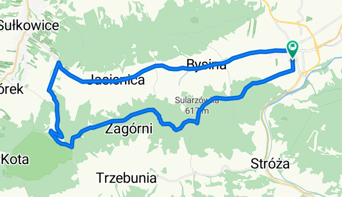
Overview
About this route
Very pleasant route, mostly runs along the red Beskid trail. Initially, a relatively difficult climb, the path is narrow, with ruts washed away by water and stones, passing through meadows, little shade, which is noticeable on a hot day. Once in the forest, it gets much better, beautiful trail, wide path, a bit of roots. Some steep climbs with loose stones, but short; in the upper parts of the trail, significant ruts filled with water, but easily avoidable. According to Garmin, the distance turned out to be shorter and the elevation gain almost 600 m. The return was entirely on asphalt (about 12 km), but it is worth it! I recommend!
- -:--
- Duration
- 24.6 km
- Distance
- 579 m
- Ascent
- 581 m
- Descent
- ---
- Avg. speed
- ---
- Max. altitude

Route quality
Waytypes & surfaces along the route
Waytypes
Track
10.6 km
(43 %)
Road
8.6 km
(35 %)
Surfaces
Paved
10.8 km
(44 %)
Unpaved
11.8 km
(48 %)
Asphalt
10.8 km
(44 %)
Ground
10.8 km
(44 %)
Route highlights
Points of interest along the route
Point of interest after 0 km
Aquarius Myślenice
Continue with Bikemap
Use, edit, or download this cycling route
You would like to ride Myślenice Aquarius or customize it for your own trip? Here is what you can do with this Bikemap route:
Free features
- Save this route as favorite or in collections
- Copy & plan your own version of this route
- Sync your route with Garmin or Wahoo
Premium features
Free trial for 3 days, or one-time payment. More about Bikemap Premium.
- Navigate this route on iOS & Android
- Export a GPX / KML file of this route
- Create your custom printout (try it for free)
- Download this route for offline navigation
Discover more Premium features.
Get Bikemap PremiumFrom our community
Other popular routes starting in Myślenice
 Najwyższe szczyty Beskidu Myslenickiego (Makowskiego)
- Distance
- 72.5 km
- Ascent
- 2,372 m
- Descent
- 2,372 m
- Location
- Myślenice, Lesser Poland Voivodeship, Poland
 2013_05_15
- Distance
- 33.7 km
- Ascent
- 0 m
- Descent
- 0 m
- Location
- Myślenice, Lesser Poland Voivodeship, Poland
 Road - Myślenice - Dookoła Jeziora Dobczyckiego 1
- Distance
- 48.9 km
- Ascent
- 461 m
- Descent
- 467 m
- Location
- Myślenice, Lesser Poland Voivodeship, Poland
 Beskid Makowski, Myślenice-Lubomir
- Distance
- 35.8 km
- Ascent
- 1,282 m
- Descent
- 1,282 m
- Location
- Myślenice, Lesser Poland Voivodeship, Poland
 Myślenice Aquarius
- Distance
- 24.6 km
- Ascent
- 579 m
- Descent
- 581 m
- Location
- Myślenice, Lesser Poland Voivodeship, Poland
 Myślenice-Kudłacze-Lubomir-2015-07-11
- Distance
- 41.6 km
- Ascent
- 1,126 m
- Descent
- 1,130 m
- Location
- Myślenice, Lesser Poland Voivodeship, Poland
 myslenice_gur2019_profil13
- Distance
- 13.4 km
- Ascent
- 445 m
- Descent
- 442 m
- Location
- Myślenice, Lesser Poland Voivodeship, Poland
 Myślenice - Lubomir - Myślenice
- Distance
- 34.5 km
- Ascent
- 806 m
- Descent
- 806 m
- Location
- Myślenice, Lesser Poland Voivodeship, Poland
Open it in the app