

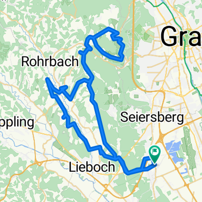
Steiermark 4 - Mooskirchen-Teigitsch-Lipizzaner-Köflach
A cycling route starting in Unterpremstätten, Styria, Austria.
Overview
About this route
TEASI Track
Lieboch-Mooskirchen-Keltenhaus-Ligist-Old Oil Mill-Teigitschgraben-Piberstein Lake-Maria Lankowitz-Köflach-Piber Stud Farm-Bärnbach-Voitsberg-Stallhofen-Bernau-Neudorf-Kleinsöding-Lieboch-Unterpremstätten
- -:--
- Duration
- 86.6 km
- Distance
- 511 m
- Ascent
- 511 m
- Descent
- ---
- Avg. speed
- ---
- Max. altitude

Route quality
Waytypes & surfaces along the route
Waytypes
Quiet road
34.6 km
(40 %)
Road
15.6 km
(18 %)
Surfaces
Paved
23.4 km
(27 %)
Unpaved
0.9 km
(1 %)
Asphalt
21.6 km
(25 %)
Paved (undefined)
1.7 km
(2 %)
Continue with Bikemap
Use, edit, or download this cycling route
You would like to ride Steiermark 4 - Mooskirchen-Teigitsch-Lipizzaner-Köflach or customize it for your own trip? Here is what you can do with this Bikemap route:
Free features
- Save this route as favorite or in collections
- Copy & plan your own version of this route
- Split it into stages to create a multi-day tour
- Sync your route with Garmin or Wahoo
Premium features
Free trial for 3 days, or one-time payment. More about Bikemap Premium.
- Navigate this route on iOS & Android
- Export a GPX / KML file of this route
- Create your custom printout (try it for free)
- Download this route for offline navigation
Discover more Premium features.
Get Bikemap PremiumFrom our community
Other popular routes starting in Unterpremstätten
 Glocknerman 2014
- Distance
- 1,054.8 km
- Ascent
- 7,201 m
- Descent
- 7,201 m
- Location
- Unterpremstätten, Styria, Austria
 Bike Graz 70.3 v003
- Distance
- 89.3 km
- Ascent
- 1,281 m
- Descent
- 1,239 m
- Location
- Unterpremstätten, Styria, Austria
 Steiermark 4 - Mooskirchen-Teigitsch-Lipizzaner-Köflach
- Distance
- 86.6 km
- Ascent
- 511 m
- Descent
- 511 m
- Location
- Unterpremstätten, Styria, Austria
 Kalsdorf - Muttendorf - Dobl - Unterpremstätten
- Distance
- 46.9 km
- Ascent
- 239 m
- Descent
- 249 m
- Location
- Unterpremstätten, Styria, Austria
 Steiermark 2 - Westl. Steiermark
- Distance
- 56.4 km
- Ascent
- 535 m
- Descent
- 535 m
- Location
- Unterpremstätten, Styria, Austria
 Südsteiermark
- Distance
- 90.1 km
- Ascent
- 528 m
- Descent
- 636 m
- Location
- Unterpremstätten, Styria, Austria
 Unterwegs auf teilweise schottrigen Feldwegen
- Distance
- 25.7 km
- Ascent
- 83 m
- Descent
- 79 m
- Location
- Unterpremstätten, Styria, Austria
 UP-Feldkirchen-Graz-Thal/Eben-Steinberg-Hitzendorf-Doblegg-Tobelbad-Dobl-Zwaring-Wundschuh-SFZ
- Distance
- 64.8 km
- Ascent
- 420 m
- Descent
- 438 m
- Location
- Unterpremstätten, Styria, Austria
Open it in the app