

20150620_134656.gpx
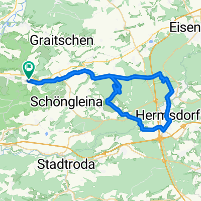
A cycling route starting in Großlöbichau, Thuringia, Germany.
Overview
About this route
TEASI track
- -:--
- Duration
- 29.7 km
- Distance
- 201 m
- Ascent
- 201 m
- Descent
- ---
- Avg. speed
- ---
- Max. altitude
Route quality
Waytypes & surfaces along the route
Waytypes
Quiet road
8.6 km
(29 %)
Track
7.1 km
(24 %)
Surfaces
Paved
22 km
(74 %)
Unpaved
3.9 km
(13 %)
Asphalt
21.7 km
(73 %)
Loose gravel
2.1 km
(7 %)
Continue with Bikemap
Use, edit, or download this cycling route
You would like to ride 20150620_134656.gpx or customize it for your own trip? Here is what you can do with this Bikemap route:
Free features
- Save this route as favorite or in collections
- Copy & plan your own version of this route
- Sync your route with Garmin or Wahoo
Premium features
Free trial for 3 days, or one-time payment. More about Bikemap Premium.
- Navigate this route on iOS & Android
- Export a GPX / KML file of this route
- Create your custom printout (try it for free)
- Download this route for offline navigation
Discover more Premium features.
Get Bikemap PremiumFrom our community
Other popular routes starting in Großlöbichau
 Holzlandrunde
- Distance
- 39.4 km
- Ascent
- 382 m
- Descent
- 386 m
- Location
- Großlöbichau, Thuringia, Germany
 Großlöbichau-Silberthal
- Distance
- 22.2 km
- Ascent
- 269 m
- Descent
- 245 m
- Location
- Großlöbichau, Thuringia, Germany
 Bad Kösen
- Distance
- 73.1 km
- Ascent
- 665 m
- Descent
- 667 m
- Location
- Großlöbichau, Thuringia, Germany
 Horizontale zur 100km Wanderung
- Distance
- 10.1 km
- Ascent
- 461 m
- Descent
- 460 m
- Location
- Großlöbichau, Thuringia, Germany
 20090412 Holzland
- Distance
- 46.1 km
- Ascent
- 568 m
- Descent
- 566 m
- Location
- Großlöbichau, Thuringia, Germany
 Radweg Großlöbichau-Bürgel-Hainspitz und zurück
- Distance
- 32.4 km
- Ascent
- 303 m
- Descent
- 305 m
- Location
- Großlöbichau, Thuringia, Germany
 Ostrunde1
- Distance
- 38.6 km
- Ascent
- 364 m
- Descent
- 342 m
- Location
- Großlöbichau, Thuringia, Germany
 Ausflug mit KaffeePause
- Distance
- 27 km
- Ascent
- 173 m
- Descent
- 179 m
- Location
- Großlöbichau, Thuringia, Germany
Open it in the app