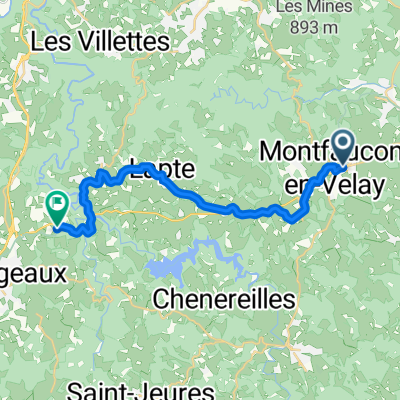
Katia & Pascal, cortège
A cycling route starting in Montfaucon-en-Velay, Auvergne-RhĂ´ne-Alpes, France.
Overview
About this route
<3
- -:--
- Duration
- 13.2 km
- Distance
- 247 m
- Ascent
- 240 m
- Descent
- ---
- Avg. speed
- ---
- Max. altitude
Route quality
Waytypes & surfaces along the route
Waytypes
Quiet road
3.4 km
(26 %)
Access road
0.1 km
(1 %)
Undefined
9.6 km
(73 %)
Surfaces
Paved
3.2 km
(24 %)
Asphalt
3.2 km
(24 %)
Undefined
10 km
(76 %)
Route highlights
Points of interest along the route
Point of interest after 0 km
Mairie + cérémonie
Point of interest after 3.3 km
Aulagny
Continue with Bikemap
Use, edit, or download this cycling route
You would like to ride Katia & Pascal, cortège or customize it for your own trip? Here is what you can do with this Bikemap route:
Free features
- Save this route as favorite or in collections
- Copy & plan your own version of this route
- Sync your route with Garmin or Wahoo
Premium features
Free trial for 3 days, or one-time payment. More about Bikemap Premium.
- Navigate this route on iOS & Android
- Export a GPX / KML file of this route
- Create your custom printout (try it for free)
- Download this route for offline navigation
Discover more Premium features.
Get Bikemap PremiumFrom our community
Other popular routes starting in Montfaucon-en-Velay
- 2023 Bahntrasse Dunieres----Riotard
- Distance
- 34.7 km
- Ascent
- ---
- Descent
- ---
- Location
- Montfaucon-en-Velay, Auvergne-RhĂ´ne-Alpes, France
- Montregard, Riotord, St Julien, St Bonnet
- Distance
- 50.6 km
- Ascent
- 716 m
- Descent
- 716 m
- Location
- Montfaucon-en-Velay, Auvergne-RhĂ´ne-Alpes, France
- 215 Route de la Gare, Raucoules nach 54bis Grande Rue, St.-Pierre-de-Boeuf
- Distance
- 53 km
- Ascent
- 475 m
- Descent
- 1,167 m
- Location
- Montfaucon-en-Velay, Auvergne-RhĂ´ne-Alpes, France
- 43 La Gare Raucoules à La Maisonneuve, Riotord tunnel fermé
- Distance
- 19 km
- Ascent
- 333 m
- Descent
- 289 m
- Location
- Montfaucon-en-Velay, Auvergne-RhĂ´ne-Alpes, France
- Montregard, Col de la Charousse
- Distance
- 104.8 km
- Ascent
- 1,453 m
- Descent
- 1,454 m
- Location
- Montfaucon-en-Velay, Auvergne-RhĂ´ne-Alpes, France
- Mountfaucon - Le Puy en Velay Teil 4
- Distance
- 56.4 km
- Ascent
- 615 m
- Descent
- 889 m
- Location
- Montfaucon-en-Velay, Auvergne-RhĂ´ne-Alpes, France
- f_via_gebennensis_014
- Distance
- 19.6 km
- Ascent
- 400 m
- Descent
- 276 m
- Location
- Montfaucon-en-Velay, Auvergne-RhĂ´ne-Alpes, France
- Katia & Pascal, cortège
- Distance
- 13.2 km
- Ascent
- 247 m
- Descent
- 240 m
- Location
- Montfaucon-en-Velay, Auvergne-RhĂ´ne-Alpes, France
Open it in the app