

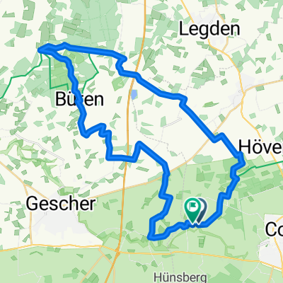
Coesfeld 34 - Gut Ross-Tour
A cycling route starting in Coesfeld, North Rhine-Westphalia, Germany.
Overview
About this route
TEASI track
- -:--
- Duration
- 41.8 km
- Distance
- 63 m
- Ascent
- 63 m
- Descent
- ---
- Avg. speed
- ---
- Max. altitude
Route quality
Waytypes & surfaces along the route
Waytypes
Quiet road
36 km
(86 %)
Path
2.5 km
(6 %)
Surfaces
Paved
20.1 km
(48 %)
Unpaved
3.8 km
(9 %)
Asphalt
20.1 km
(48 %)
Gravel
2.1 km
(5 %)
Continue with Bikemap
Use, edit, or download this cycling route
You would like to ride Coesfeld 34 - Gut Ross-Tour or customize it for your own trip? Here is what you can do with this Bikemap route:
Free features
- Save this route as favorite or in collections
- Copy & plan your own version of this route
- Sync your route with Garmin or Wahoo
Premium features
Free trial for 3 days, or one-time payment. More about Bikemap Premium.
- Navigate this route on iOS & Android
- Export a GPX / KML file of this route
- Create your custom printout (try it for free)
- Download this route for offline navigation
Discover more Premium features.
Get Bikemap PremiumFrom our community
Other popular routes starting in Coesfeld
 EV 2 Coesfeld - Münster
- Distance
- 54.5 km
- Ascent
- 130 m
- Descent
- 154 m
- Location
- Coesfeld, North Rhine-Westphalia, Germany
 Von Coesfeld bis Menden (Sauerland)
- Distance
- 95.6 km
- Ascent
- 438 m
- Descent
- 356 m
- Location
- Coesfeld, North Rhine-Westphalia, Germany
 Route in Coesfeld
- Distance
- 36.4 km
- Ascent
- 163 m
- Descent
- 161 m
- Location
- Coesfeld, North Rhine-Westphalia, Germany
 Benny's Baumbergetocht
- Distance
- 92.2 km
- Ascent
- 719 m
- Descent
- 719 m
- Location
- Coesfeld, North Rhine-Westphalia, Germany
 RTF Coesfeld 112km 2009
- Distance
- 115.5 km
- Ascent
- 500 m
- Descent
- 490 m
- Location
- Coesfeld, North Rhine-Westphalia, Germany
 Markt nach Am Roten Baum
- Distance
- 19.5 km
- Ascent
- 65 m
- Descent
- 104 m
- Location
- Coesfeld, North Rhine-Westphalia, Germany
 Goxel-Waldfrieden
- Distance
- 17.5 km
- Ascent
- 79 m
- Descent
- 101 m
- Location
- Coesfeld, North Rhine-Westphalia, Germany
 KREUZWEG TOUR
- Distance
- 15.5 km
- Ascent
- 48 m
- Descent
- 46 m
- Location
- Coesfeld, North Rhine-Westphalia, Germany
Open it in the app