
Haselbachtal, Leinecksee
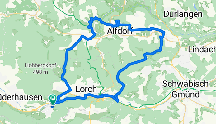
A cycling route starting in Lorch, Baden-Württemberg, Germany.
Overview
About this route
Durchs Haselbachtal über Pfersbach, an Adelstetten vorbei, Bonholz, um Alfdorf herum über Brend aus nördlicher Richtung zum Leinecksee. Durch Pfahlbronn über Strauben ins Walkersbacher Tal und zurück nach Waldhausen.
- -:--
- Duration
- 36 km
- Distance
- 393 m
- Ascent
- 390 m
- Descent
- ---
- Avg. speed
- ---
- Max. altitude
Route quality
Waytypes & surfaces along the route
Waytypes
Quiet road
17.5 km
(48 %)
Track
13.6 km
(38 %)
Surfaces
Paved
28.9 km
(80 %)
Unpaved
4.6 km
(13 %)
Asphalt
23.9 km
(66 %)
Paved (undefined)
5 km
(14 %)
Continue with Bikemap
Use, edit, or download this cycling route
You would like to ride Haselbachtal, Leinecksee or customize it for your own trip? Here is what you can do with this Bikemap route:
Free features
- Save this route as favorite or in collections
- Copy & plan your own version of this route
- Sync your route with Garmin or Wahoo
Premium features
Free trial for 3 days, or one-time payment. More about Bikemap Premium.
- Navigate this route on iOS & Android
- Export a GPX / KML file of this route
- Create your custom printout (try it for free)
- Download this route for offline navigation
Discover more Premium features.
Get Bikemap PremiumFrom our community
Other popular routes starting in Lorch
 Walkersbach Bärenbach Badeseen - Walkersbach Bärenbach Badeseen
- Distance
- 19.9 km
- Ascent
- 344 m
- Descent
- 344 m
- Location
- Lorch, Baden-Württemberg, Germany
 Lorch-Haselbach
- Distance
- 18.6 km
- Ascent
- 291 m
- Descent
- 294 m
- Location
- Lorch, Baden-Württemberg, Germany
 Feierabendtour Rattenharz
- Distance
- 21.3 km
- Ascent
- 263 m
- Descent
- 263 m
- Location
- Lorch, Baden-Württemberg, Germany
 Rundstrecke von Lorch
- Distance
- 86.3 km
- Ascent
- 1,269 m
- Descent
- 1,213 m
- Location
- Lorch, Baden-Württemberg, Germany
 Lorch-Kaisersträßle-Schorndorf-Remsweg-Lorch
- Distance
- 41.1 km
- Ascent
- 285 m
- Descent
- 282 m
- Location
- Lorch, Baden-Württemberg, Germany
 Hohbergrunde
- Distance
- 23.5 km
- Ascent
- 536 m
- Descent
- 469 m
- Location
- Lorch, Baden-Württemberg, Germany
 Welzheim-Himmelreich-Wäschenbeuren
- Distance
- 77.3 km
- Ascent
- 743 m
- Descent
- 745 m
- Location
- Lorch, Baden-Württemberg, Germany
 Lorch/Haselbachtal-Fichtenberg Bhf.
- Distance
- 28.2 km
- Ascent
- 550 m
- Descent
- 496 m
- Location
- Lorch, Baden-Württemberg, Germany
Open it in the app