
20160508_084644.gpx
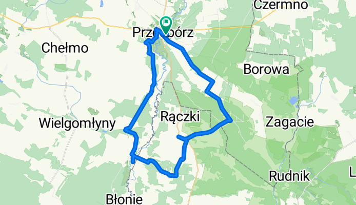
A cycling route starting in Gmina Przedbórz, Łódź Voivodeship, Poland.
Overview
About this route
TEASI track
- -:--
- Duration
- 46.2 km
- Distance
- 204 m
- Ascent
- 204 m
- Descent
- ---
- Avg. speed
- ---
- Max. altitude
Route quality
Waytypes & surfaces along the route
Waytypes
Quiet road
30.5 km
(66 %)
Road
7.9 km
(17 %)
Surfaces
Paved
34.7 km
(75 %)
Unpaved
2.3 km
(5 %)
Asphalt
34.7 km
(75 %)
Ground
2.3 km
(5 %)
Undefined
9.2 km
(20 %)
Continue with Bikemap
Use, edit, or download this cycling route
You would like to ride 20160508_084644.gpx or customize it for your own trip? Here is what you can do with this Bikemap route:
Free features
- Save this route as favorite or in collections
- Copy & plan your own version of this route
- Sync your route with Garmin or Wahoo
Premium features
Free trial for 3 days, or one-time payment. More about Bikemap Premium.
- Navigate this route on iOS & Android
- Export a GPX / KML file of this route
- Create your custom printout (try it for free)
- Download this route for offline navigation
Discover more Premium features.
Get Bikemap PremiumFrom our community
Other popular routes starting in Gmina Przedbórz
 Przedbórz-Kozia-Krzętów-Przedbórz 2
- Distance
- 68.1 km
- Ascent
- 141 m
- Descent
- 141 m
- Location
- Gmina Przedbórz, Łódź Voivodeship, Poland
 20160731_084606.gpx
- Distance
- 100.9 km
- Ascent
- 261 m
- Descent
- 261 m
- Location
- Gmina Przedbórz, Łódź Voivodeship, Poland
 Krzętów - Tychy
- Distance
- 156.8 km
- Ascent
- 481 m
- Descent
- 419 m
- Location
- Gmina Przedbórz, Łódź Voivodeship, Poland
 spływ Warta Przedbórz - Biała 19.05.2018
- Distance
- 33.2 km
- Ascent
- 40 m
- Descent
- 58 m
- Location
- Gmina Przedbórz, Łódź Voivodeship, Poland
 biały brzeg-stanica
- Distance
- 41.8 km
- Ascent
- 173 m
- Descent
- 156 m
- Location
- Gmina Przedbórz, Łódź Voivodeship, Poland
 Cegielniana 15, Przedbórz do Góry Mokre 110a, Góry Mokre
- Distance
- 14 km
- Ascent
- 74 m
- Descent
- 36 m
- Location
- Gmina Przedbórz, Łódź Voivodeship, Poland
 Przedbórz-Kozia-Krzętów-Przedbórz
- Distance
- 57.5 km
- Ascent
- 167 m
- Descent
- 166 m
- Location
- Gmina Przedbórz, Łódź Voivodeship, Poland
 Trytwa 10, Przedbórz do Mirowska 241, Częstochowa
- Distance
- 82.2 km
- Ascent
- 493 m
- Descent
- 457 m
- Location
- Gmina Przedbórz, Łódź Voivodeship, Poland
Open it in the app