

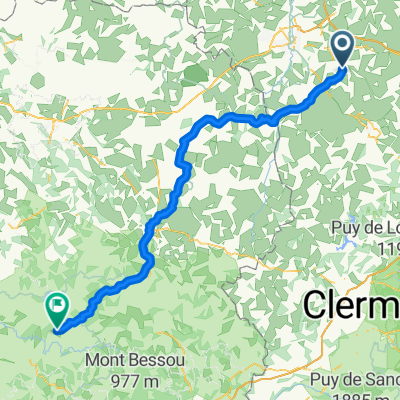
Commentry -- La Villedieu 125km 1420HM
A cycling route starting in Commentry, Auvergne-Rhône-Alpes, France.
Overview
About this route
COMMENTRY -- Rue de la Grange --bis Einmündung in D69-- (--oder Variante D69-direkt-von Commentry aus )--Les Brandes des Gouerands -- Durant-Larequilles --D69 -- geht in -- D1089 über --ca 2km vor in Terjat -- D109 --Le Gentioux -- D915 --in Chambonchard -- auf D915--Richtung " Süden" -- Eveaux-les Bains -- D915 -- in Chambon-sur Voueize -- auf D993 -- Lussat -- D55 -- St.Loup auf -- D40 -- geht in St. Julien-le-Chatel in -- D54-über -- in Peyrat-la-Noniere auf --D4-- bei Kreuzung mit D993 --auf D993 -- La Croix de L`Arbres -- D993 -- Montelladonne --Le Courtioux -- St.Amand --D993 bis ca 2km vor Aubusson bei Kreuzung mit D990A -- auf D990A -- Abussson -- "Ausfahrt" -- auf D23 -- Le Pont des Malades-- D23 --umfahren von Filletin -- bei Kreuzung mit D992 -- auf D992 -- Mairie de St. Quentin La Cabanne -- Etang de Vervialle -- Le Chiroux -- D992 --Villemoneix -- Gentioux-Pigerolles -- Faux-La-Montagne --D992 -- LA VILLEDIEUX
- -:--
- Duration
- 125 km
- Distance
- 1,200 m
- Ascent
- 980 m
- Descent
- ---
- Avg. speed
- ---
- Max. altitude
Route quality
Waytypes & surfaces along the route
Waytypes
Busy road
75.3 km
(60 %)
Road
40.9 km
(33 %)
Surfaces
Paved
55.4 km
(44 %)
Unpaved
0.1 km
(<1 %)
Asphalt
55.4 km
(44 %)
Unpaved (undefined)
0.1 km
(<1 %)
Undefined
69.5 km
(56 %)
Continue with Bikemap
Use, edit, or download this cycling route
You would like to ride Commentry -- La Villedieu 125km 1420HM or customize it for your own trip? Here is what you can do with this Bikemap route:
Free features
- Save this route as favorite or in collections
- Copy & plan your own version of this route
- Split it into stages to create a multi-day tour
- Sync your route with Garmin or Wahoo
Premium features
Free trial for 3 days, or one-time payment. More about Bikemap Premium.
- Navigate this route on iOS & Android
- Export a GPX / KML file of this route
- Create your custom printout (try it for free)
- Download this route for offline navigation
Discover more Premium features.
Get Bikemap PremiumFrom our community
Other popular routes starting in Commentry
 P2P - day 3
- Distance
- 98.8 km
- Ascent
- 2,019 m
- Descent
- 1,278 m
- Location
- Commentry, Auvergne-Rhône-Alpes, France
 essai
essai- Distance
- 25.2 km
- Ascent
- 253 m
- Descent
- 252 m
- Location
- Commentry, Auvergne-Rhône-Alpes, France
 20150524_102419.gpx
- Distance
- 31.7 km
- Ascent
- 281 m
- Descent
- 286 m
- Location
- Commentry, Auvergne-Rhône-Alpes, France
 Commentry -- La Villedieu 125km 1420HM
- Distance
- 125 km
- Ascent
- 1,200 m
- Descent
- 980 m
- Location
- Commentry, Auvergne-Rhône-Alpes, France
 20150424_100928.gpx
- Distance
- 24.1 km
- Ascent
- 208 m
- Descent
- 208 m
- Location
- Commentry, Auvergne-Rhône-Alpes, France
 20150326_172428.gpx
- Distance
- 13.7 km
- Ascent
- 97 m
- Descent
- 82 m
- Location
- Commentry, Auvergne-Rhône-Alpes, France
 20150807_085324.gpx
- Distance
- 34.2 km
- Ascent
- 251 m
- Descent
- 253 m
- Location
- Commentry, Auvergne-Rhône-Alpes, France
 CAP 03 Commentry
- Distance
- 30.1 km
- Ascent
- 1,888 m
- Descent
- 1,886 m
- Location
- Commentry, Auvergne-Rhône-Alpes, France
Open it in the app