

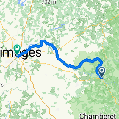
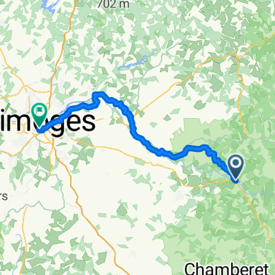
La Villedieu -- Perigeux 136 km 1080 Hm
A cycling route starting in Eymoutiers, Nouvelle-Aquitaine, France.
Overview
About this route
LA VILLEDIEU -- D992 -- Crossing with- D69 -- continue on -- D69 -- La Villeneuve --Le Mars Moury -- D69 -- turns into D132 --D132 -- crosses D940 -- continue on Prabonneau --to the crossing with D132E2 continue on --D132E2 -('South') -- crosses -- D132 -- continue on -- D132 -- Chaumeil Didier --D132 --Crossing with -- D3 --on --D3 -- Chamberet -- D132E4 --Crossing with -- D20 -- continue on --D20 -- Meilhards --D20 --Le Breuil -- D20 -- crosses -- D20E6 --then on -- D20E7 -- crosses -- D26 --continue on -- D20E7 --to the center Salon -La -Tour -- then D26 -- crosses -- D920 --continue on --D85 -- Las Fleytias -- Crossing with D85E1 --continue -- D85E1 -- La Borie-Gauthier -- crosses -- D920 --continue on --D902 -- Le Puy de Laudrerie -- D902 -- La Chabassière -- D902 --( possibly 1.5km before Lubersac::Take Rue de la Croix de Geai, 50 Hm less) -- Lubersac --D901 -- crosses -- D107 -- continue -- D107 -- crosses D6 -- D6 --crosses -- D7 (about 3km before LaCroix de Pierre)--D7 -- turns into -- D75 -- (at the crossing La Frommental) -- Crossing -- D80 --continue on -- D75-- Payzac -- D75 -- crosses D4 -- D4 --crosses -- D75E -- continue D4 --crosses - D72E4 ,-- continue on --- D4 -- Rezonac -- D4 --crosses -- D704, -- continue on D705 -- La Croix Boumade -- D7005 -- St. Médard - crosses -D76 -- continue on -- D705 -- D Èxcideuil -- D705 -- Coulaures --D705 -- crosses D74 - continue -- D74 --(near Chardeuil, with Lycée professionnel du Bâtiment, (coffee-stop?) ) -- D74 --Sorges -- crosses D68 --D68 -- about 100m, crosses with -D106 --continue on -- D106 -- after about 900m crosses - D8 -- continue -D8 --crosses - D69 -continue -- D8 -- D8-- until PERIGUEUX
- -:--
- Duration
- 135.1 km
- Distance
- 724 m
- Ascent
- 1,170 m
- Descent
- ---
- Avg. speed
- ---
- Max. altitude
Route quality
Waytypes & surfaces along the route
Waytypes
Road
51.3 km
(38 %)
Quiet road
20.3 km
(15 %)
Undefined
63.5 km
(47 %)
Surfaces
Paved
51.3 km
(38 %)
Asphalt
37.8 km
(28 %)
Paved (undefined)
13.5 km
(10 %)
Undefined
83.8 km
(62 %)
Continue with Bikemap
Use, edit, or download this cycling route
You would like to ride La Villedieu -- Perigeux 136 km 1080 Hm or customize it for your own trip? Here is what you can do with this Bikemap route:
Free features
- Save this route as favorite or in collections
- Copy & plan your own version of this route
- Split it into stages to create a multi-day tour
- Sync your route with Garmin or Wahoo
Premium features
Free trial for 3 days, or one-time payment. More about Bikemap Premium.
- Navigate this route on iOS & Android
- Export a GPX / KML file of this route
- Create your custom printout (try it for free)
- Download this route for offline navigation
Discover more Premium features.
Get Bikemap PremiumFrom our community
Other popular routes starting in Eymoutiers
 F66-Anfahrt-Eymoutiers-Las de Vassiviere-Peyrelevade-Sornac-Saint Merdles Oussines-Lacelle-Eymoutiers
- Distance
- 131.8 km
- Ascent
- 1,055 m
- Descent
- 1,053 m
- Location
- Eymoutiers, Nouvelle-Aquitaine, France
 Global - La Vélidéale - E1
- Distance
- 70.1 km
- Ascent
- 1,183 m
- Descent
- 1,333 m
- Location
- Eymoutiers, Nouvelle-Aquitaine, France
 Tour de France 20. Etappe Eymoutiers - Lac de Vassiviere
- Distance
- 30.1 km
- Ascent
- 658 m
- Descent
- 404 m
- Location
- Eymoutiers, Nouvelle-Aquitaine, France
 Étape 2: Serre - Mont Dore
- Distance
- 121.5 km
- Ascent
- 1,446 m
- Descent
- 719 m
- Location
- Eymoutiers, Nouvelle-Aquitaine, France
 Eymoutiers-Mont-Dore
- Distance
- 110.9 km
- Ascent
- 1,334 m
- Descent
- 713 m
- Location
- Eymoutiers, Nouvelle-Aquitaine, France
 La Villedieu -- Perigeux 136 km 1080 Hm
- Distance
- 135.1 km
- Ascent
- 724 m
- Descent
- 1,170 m
- Location
- Eymoutiers, Nouvelle-Aquitaine, France
 From Eymoutiers to Limoges
- Distance
- 60.8 km
- Ascent
- 877 m
- Descent
- 1,022 m
- Location
- Eymoutiers, Nouvelle-Aquitaine, France
 De Chemin du Buchou 1, Eymoutiers à Le Bourg, Grandsaigne
- Distance
- 49.2 km
- Ascent
- 1,310 m
- Descent
- 1,137 m
- Location
- Eymoutiers, Nouvelle-Aquitaine, France
Open it in the app