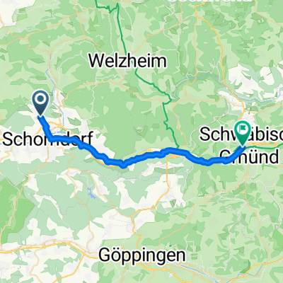
SCHORN LANGENARGEN
A cycling route starting in Schorndorf, Baden-Wurttemberg, Germany.
Overview
About this route
TEASI track
- -:--
- Duration
- 207.5 km
- Distance
- 949 m
- Ascent
- 809 m
- Descent
- ---
- Avg. speed
- ---
- Max. altitude
Route quality
Waytypes & surfaces along the route
Waytypes
Quiet road
62.3 km
(30 %)
Track
49.8 km
(24 %)
Surfaces
Paved
168.1 km
(81 %)
Unpaved
20.8 km
(10 %)
Asphalt
166 km
(80 %)
Gravel
12.5 km
(6 %)
Route highlights
Points of interest along the route
Point of interest after 0 km
Stadtzentrum
Point of interest after 85.7 km
Stadtzentrum
Point of interest after 153.3 km
Stadtzentrum
Point of interest after 207.5 km
Stadtzentrum
Continue with Bikemap
Use, edit, or download this cycling route
You would like to ride SCHORN LANGENARGEN or customize it for your own trip? Here is what you can do with this Bikemap route:
Free features
- Save this route as favorite or in collections
- Copy & plan your own version of this route
- Split it into stages to create a multi-day tour
- Sync your route with Garmin or Wahoo
Premium features
Free trial for 3 days, or one-time payment. More about Bikemap Premium.
- Navigate this route on iOS & Android
- Export a GPX / KML file of this route
- Create your custom printout (try it for free)
- Download this route for offline navigation
Discover more Premium features.
Get Bikemap PremiumFrom our community
Other popular routes starting in Schorndorf
- Rund um Schorndorf
- Distance
- 54.2 km
- Ascent
- 948 m
- Descent
- 976 m
- Location
- Schorndorf, Baden-Wurttemberg, Germany
- Schorndorf-Berglen-Gmünd
- Distance
- 80.9 km
- Ascent
- 884 m
- Descent
- 883 m
- Location
- Schorndorf, Baden-Wurttemberg, Germany
- Schdf-Buoch-Kleinheppach-Rems-Schdf
- Distance
- 32.9 km
- Ascent
- 354 m
- Descent
- 353 m
- Location
- Schorndorf, Baden-Wurttemberg, Germany
- Königliche Jagd
- Distance
- 35 km
- Ascent
- 501 m
- Descent
- 502 m
- Location
- Schorndorf, Baden-Wurttemberg, Germany
- Schdf-Schnait-Weinstadt-Schdf
- Distance
- 30.8 km
- Ascent
- 450 m
- Descent
- 453 m
- Location
- Schorndorf, Baden-Wurttemberg, Germany
- Von Schorndorf bis Stuttgart
- Distance
- 46.4 km
- Ascent
- 235 m
- Descent
- 252 m
- Location
- Schorndorf, Baden-Wurttemberg, Germany
- Naturparktour
- Distance
- 50.3 km
- Ascent
- 786 m
- Descent
- 642 m
- Location
- Schorndorf, Baden-Wurttemberg, Germany
- Schorndorf - Winnenden
- Distance
- 24.5 km
- Ascent
- 155 m
- Descent
- 120 m
- Location
- Schorndorf, Baden-Wurttemberg, Germany
Open it in the app