Randen van NL Zuid Tot aan Vlissingen
A cycling route starting in Amsterdam-Zuidoost, North Holland, The Netherlands.
Overview
About this route
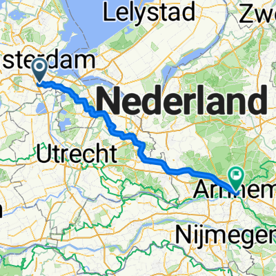
Tour Amsterdam Zwolle Arnhem and further south
- -:--
- Duration
- 575.3 km
- Distance
- 78 m
- Ascent
- 78 m
- Descent
- ---
- Avg. speed
- ---
- Max. altitude
Route quality
Waytypes & surfaces along the route
Waytypes
Quiet road
230.1 km
(40 %)
Cycleway
224.4 km
(39 %)
Surfaces
Paved
316.4 km
(55 %)
Unpaved
23 km
(4 %)
Asphalt
276.1 km
(48 %)
Concrete
34.5 km
(6 %)
Route highlights
Points of interest along the route
Point of interest after 236.2 km
Natuur kamping
Continue with Bikemap
Use, edit, or download this cycling route
You would like to ride Randen van NL Zuid Tot aan Vlissingen or customize it for your own trip? Here is what you can do with this Bikemap route:
Free features
- Save this route as favorite or in collections
- Copy & plan your own version of this route
- Split it into stages to create a multi-day tour
- Sync your route with Garmin or Wahoo
Premium features
Free trial for 3 days, or one-time payment. More about Bikemap Premium.
- Navigate this route on iOS & Android
- Export a GPX / KML file of this route
- Create your custom printout (try it for free)
- Download this route for offline navigation
Discover more Premium features.
Get Bikemap PremiumFrom our community
Other popular routes starting in Amsterdam-Zuidoost
- De Karspeldreef 17, Ámsterdam a Amsterdamseweg 468A, Amstelveen
- Distance
- 10.1 km
- Ascent
- 31 m
- Descent
- 20 m
- Location
- Amsterdam-Zuidoost, North Holland, The Netherlands
- 🇳🇱 HB D02 - Amsterdam (72km)
- Distance
- 71.5 km
- Ascent
- 61 m
- Descent
- 59 m
- Location
- Amsterdam-Zuidoost, North Holland, The Netherlands
- Waterlinie-route_370km
- Distance
- 357.5 km
- Ascent
- 0 m
- Descent
- 0 m
- Location
- Amsterdam-Zuidoost, North Holland, The Netherlands
- Naar Costa Del Zeumeren
- Distance
- 61 km
- Ascent
- 94 m
- Descent
- 77 m
- Location
- Amsterdam-Zuidoost, North Holland, The Netherlands
- Holendrecht - Julianapark Utrecht 30 km
- Distance
- 30.2 km
- Ascent
- 34 m
- Descent
- 28 m
- Location
- Amsterdam-Zuidoost, North Holland, The Netherlands
- Amsterdam - Utrecht
- Distance
- 35.6 km
- Ascent
- 16 m
- Descent
- 10 m
- Location
- Amsterdam-Zuidoost, North Holland, The Netherlands
- Route to Costa Del Zeumeren
- Distance
- 60.8 km
- Ascent
- 54 m
- Descent
- 37 m
- Location
- Amsterdam-Zuidoost, North Holland, The Netherlands
- Rondje Veen - Water - Rails - Weiland
- Distance
- 46 km
- Ascent
- 0 m
- Descent
- 0 m
- Location
- Amsterdam-Zuidoost, North Holland, The Netherlands
Open it in the app