
Steyr - Ennstal - Ramingtal
A cycling route starting in Steyr, Upper Austria, Austria.
Overview
About this route
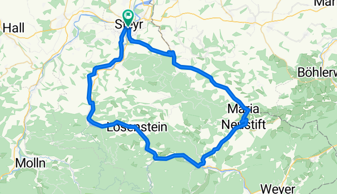
Von Steyr aus fährt man über Garsten am Ennstalradweg bis Großraming. Dann gehts links in den Neustiftgraben und den "Berg" hoch nach Maria Neustift. Anschließend geht es im Ramingtal fast durchgehend leicht bergab bis nach Kleinraming, wo man links Richtung Gasthaus Nell abbiegt und nochmal einen "Berg" hochfährt. Danach über St.Ulrich bergab nach Steyr zurückrollt
- -:--
- Duration
- 66.3 km
- Distance
- 1,108 m
- Ascent
- 971 m
- Descent
- ---
- Avg. speed
- 620 m
- Max. altitude

Route quality
Waytypes & surfaces along the route
Waytypes
Road
17.2 km
(26 %)
Quiet road
8 km
(12 %)
Surfaces
Paved
50.4 km
(76 %)
Asphalt
43.1 km
(65 %)
Paved (undefined)
7.3 km
(11 %)
Undefined
15.9 km
(24 %)
Continue with Bikemap
Use, edit, or download this cycling route
You would like to ride Steyr - Ennstal - Ramingtal or customize it for your own trip? Here is what you can do with this Bikemap route:
Free features
- Save this route as favorite or in collections
- Copy & plan your own version of this route
- Sync your route with Garmin or Wahoo
Premium features
Free trial for 3 days, or one-time payment. More about Bikemap Premium.
- Navigate this route on iOS & Android
- Export a GPX / KML file of this route
- Create your custom printout (try it for free)
- Download this route for offline navigation
Discover more Premium features.
Get Bikemap PremiumFrom our community
Other popular routes starting in Steyr
 Damberg Time Trial (Profactor Teststrecke)
- Distance
- 11.3 km
- Ascent
- 481 m
- Descent
- 60 m
- Location
- Steyr, Upper Austria, Austria
 Fit in den Frühling
- Distance
- 39.2 km
- Ascent
- 686 m
- Descent
- 600 m
- Location
- Steyr, Upper Austria, Austria
 Projekt 3000
- Distance
- 102.9 km
- Ascent
- 4,695 m
- Descent
- 4,565 m
- Location
- Steyr, Upper Austria, Austria
 Steel-Town-Man extended
- Distance
- 72.5 km
- Ascent
- 664 m
- Descent
- 662 m
- Location
- Steyr, Upper Austria, Austria
 Spadenberg Special
- Distance
- 46 km
- Ascent
- 1,031 m
- Descent
- 1,027 m
- Location
- Steyr, Upper Austria, Austria
 Pöchhacker Steyr - Reichraming - retour. Ennsradweg.
- Distance
- 66.3 km
- Ascent
- 657 m
- Descent
- 664 m
- Location
- Steyr, Upper Austria, Austria
 Steyrtalweg-Hintergebirgsweg
- Distance
- 164.2 km
- Ascent
- 3,438 m
- Descent
- 3,440 m
- Location
- Steyr, Upper Austria, Austria
 Steyr - Schoberstein
- Distance
- 28.6 km
- Ascent
- 1,010 m
- Descent
- 349 m
- Location
- Steyr, Upper Austria, Austria
Open it in the app