
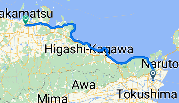
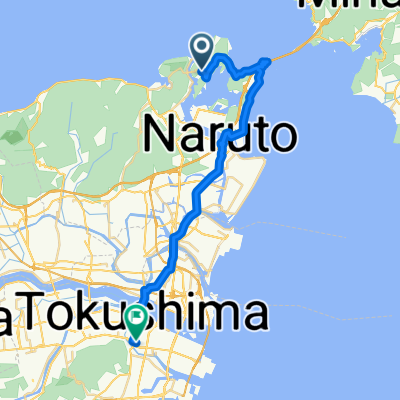
Japan Day 2
A cycling route starting in Narutochō-mitsuishi, Tokushima, Japan.
Overview
About this route
- -:--
- Duration
- 77.2 km
- Distance
- 386 m
- Ascent
- 384 m
- Descent
- ---
- Avg. speed
- ---
- Max. altitude

Route quality
Waytypes & surfaces along the route
Waytypes
Quiet road
31.7 km
(41 %)
Cycleway
13.1 km
(17 %)
Surfaces
Paved
0.8 km
(1 %)
Asphalt
0.8 km
(1 %)
Undefined
76.4 km
(99 %)
Continue with Bikemap
Use, edit, or download this cycling route
You would like to ride Japan Day 2 or customize it for your own trip? Here is what you can do with this Bikemap route:
Free features
- Save this route as favorite or in collections
- Copy & plan your own version of this route
- Sync your route with Garmin or Wahoo
Premium features
Free trial for 3 days, or one-time payment. More about Bikemap Premium.
- Navigate this route on iOS & Android
- Export a GPX / KML file of this route
- Create your custom printout (try it for free)
- Download this route for offline navigation
Discover more Premium features.
Get Bikemap PremiumFrom our community
Other popular routes starting in Narutochō-mitsuishi
 鳴門市シティコース(短距離)
- Distance
- 30.6 km
- Ascent
- 312 m
- Descent
- 310 m
- Location
- Narutochō-mitsuishi, Tokushima, Japan
 Relaxed route in Naruto-Shi
- Distance
- 7.2 km
- Ascent
- 4 m
- Descent
- 0 m
- Location
- Narutochō-mitsuishi, Tokushima, Japan
 Kuroyama, Naruto to Kita, Naruto
- Distance
- 51.2 km
- Ascent
- 550 m
- Descent
- 552 m
- Location
- Narutochō-mitsuishi, Tokushima, Japan
 トライアングルコース(山)鳴門市
- Distance
- 17.7 km
- Ascent
- 42 m
- Descent
- 40 m
- Location
- Narutochō-mitsuishi, Tokushima, Japan
 撫養町大桑島北ノ浜8-2, 鳴門市 to 中喜来稲本, 板野郡松茂町
- Distance
- 12.7 km
- Ascent
- 28 m
- Descent
- 25 m
- Location
- Narutochō-mitsuishi, Tokushima, Japan
 shikoku trip day3
- Distance
- 36.6 km
- Ascent
- 108 m
- Descent
- 97 m
- Location
- Narutochō-mitsuishi, Tokushima, Japan
 鳴門サイクリング
- Distance
- 32.4 km
- Ascent
- 263 m
- Descent
- 260 m
- Location
- Narutochō-mitsuishi, Tokushima, Japan
 jdjsk
jdjsk- Distance
- 31.1 km
- Ascent
- 315 m
- Descent
- 317 m
- Location
- Narutochō-mitsuishi, Tokushima, Japan
Open it in the app