

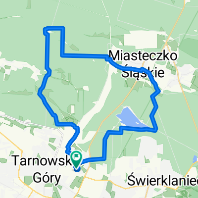
Tour de Pologne 2016 Stage 2: 149 km Tarnowskie Góry - Katowice
A cycling route starting in Tarnowskie Góry, Silesian Voivodeship, Poland.
Overview
About this route
{Wednesday 13 July}
The second day of the competition is a classic flat stage, over which sprinters should play the main role. The riders will start from Tarnowskie Góry and will ride south, discovering the scenic features of Upper Silesia. Along the way, they will compete for three sprint primes in Piekary Śląskie, Chorzów and Siemianowice Śląskie and a Special Prime in Bytom. In Katowice, there are two mountain primes. There too, fans can expect a thrilling finish at the Spodek Arena, where the riders will be hitting 80 km/h. After all, Katowice is the cycling world’s sprint Mecca.
- Stage description taken from the official Tour de Pologne website
Stage overview
- -:--
- Duration
- 92.9 km
- Distance
- 337 m
- Ascent
- 373 m
- Descent
- ---
- Avg. speed
- ---
- Max. altitude

Route quality
Waytypes & surfaces along the route
Waytypes
Road
41.8 km
(45 %)
Quiet road
17.6 km
(19 %)
Surfaces
Paved
75.2 km
(81 %)
Unpaved
0.9 km
(1 %)
Asphalt
72.5 km
(78 %)
Paved (undefined)
2.8 km
(3 %)
Continue with Bikemap
Use, edit, or download this cycling route
You would like to ride Tour de Pologne 2016 Stage 2: 149 km Tarnowskie Góry - Katowice or customize it for your own trip? Here is what you can do with this Bikemap route:
Free features
- Save this route as favorite or in collections
- Copy & plan your own version of this route
- Split it into stages to create a multi-day tour
- Sync your route with Garmin or Wahoo
Premium features
Free trial for 3 days, or one-time payment. More about Bikemap Premium.
- Navigate this route on iOS & Android
- Export a GPX / KML file of this route
- Create your custom printout (try it for free)
- Download this route for offline navigation
Discover more Premium features.
Get Bikemap PremiumFrom our community
Other popular routes starting in Tarnowskie Góry
 Single Chechelskie 1
- Distance
- 5 km
- Ascent
- 17 m
- Descent
- 29 m
- Location
- Tarnowskie Góry, Silesian Voivodeship, Poland
 Świerklaniec - Ossy
- Distance
- 27.8 km
- Ascent
- 123 m
- Descent
- 127 m
- Location
- Tarnowskie Góry, Silesian Voivodeship, Poland
 Zalew Nakło-Chechło
- Distance
- 37.2 km
- Ascent
- 135 m
- Descent
- 135 m
- Location
- Tarnowskie Góry, Silesian Voivodeship, Poland
 Tour de Pologne 2016 Stage 2: 149 km Tarnowskie Góry - Katowice
- Distance
- 92.9 km
- Ascent
- 337 m
- Descent
- 373 m
- Location
- Tarnowskie Góry, Silesian Voivodeship, Poland
 Leśno Rajza 2 (55km)
- Distance
- 54.1 km
- Ascent
- 174 m
- Descent
- 174 m
- Location
- Tarnowskie Góry, Silesian Voivodeship, Poland
 Szosa 21km Repty-Rybna-Ptakowice-Repty
- Distance
- 21.2 km
- Ascent
- 125 m
- Descent
- 126 m
- Location
- Tarnowskie Góry, Silesian Voivodeship, Poland
 Do dawnej kopalni rud
- Distance
- 49.9 km
- Ascent
- 3,818 m
- Descent
- 3,771 m
- Location
- Tarnowskie Góry, Silesian Voivodeship, Poland
 Głęboki dół
- Distance
- 25.7 km
- Ascent
- 75 m
- Descent
- 78 m
- Location
- Tarnowskie Góry, Silesian Voivodeship, Poland
Open it in the app