

Bei 30° und Ostwind nach drüben
A cycling route starting in Bayenthal, North Rhine-Westphalia, Germany.
Overview
About this route
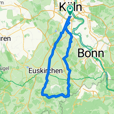
We start off at the container. Down to the Rhine and up over the bridge, then through Westhoven Ensen to Gremberghoven (under seven bridges). The east wind is hardly noticeable as a headwind since we are protected by buildings. Behind Heumar it gets green and shady. Once right, once left and then we are on Rösrather Straße – for a change, uphill. The bike path is quite alright, steadily rising and nicely shaded.
Through Stümpen we zigzag and reach the motorway bridge on a scenically very valuable and wooded route through Stephansheide, Hasbach and Schefferei into the Wahner Heide.
Once we are out, we come onto the road that circles the airport (for me, that’s the Panzerstraße). Gentlemen, now there is only one thing to do: chain all the way to the right for about 10 km. The wind pushes strongly and anyone who doesn’t let out a yell of joy (especially in the right turn before the crosswind runway) is completely insensitive. On the mouse path the fun is over but the tailwind is still there. Turn left onto Hirschgraben and then we are back in the city. The Frankfurt is quite charm free but at least it has a bike lane.
At “Kentucky schreit ficken” turn left onto my beloved ADP. At the end, turn left onto the bike path. Under the bridge, shift up immediately, as there is 20 m with a steep gradient. Passing the Gremberger Wäldchen (caution: there’s often a closed barrier there on Sundays) until we reach Siegburger. To the right and immediately back left, we dive into the city of Poll and cruise along the Rhine until the northern entrance to the Rodenkirchener Bridge. Managing that shouldn’t be a problem after this tour. On the way home, we don’t take the shortest route but ride through Marienburg and Bayenthal to Alteburger/Container.
Conclusion: Cpt. Slow felt quite quick with nearly 3 hours (the return from ADP was actually just cooling down) – which doesn’t mean anything – and enjoyed it very much.
- -:--
- Duration
- 55.7 km
- Distance
- 144 m
- Ascent
- 146 m
- Descent
- ---
- Avg. speed
- ---
- Max. altitude

Route quality
Waytypes & surfaces along the route
Waytypes
Path
18.9 km
(34 %)
Quiet road
17.8 km
(32 %)
Surfaces
Paved
46.8 km
(84 %)
Unpaved
0.6 km
(1 %)
Asphalt
45.1 km
(81 %)
Paved (undefined)
1.7 km
(3 %)
Continue with Bikemap
Use, edit, or download this cycling route
You would like to ride Bei 30° und Ostwind nach drüben or customize it for your own trip? Here is what you can do with this Bikemap route:
Free features
- Save this route as favorite or in collections
- Copy & plan your own version of this route
- Sync your route with Garmin or Wahoo
Premium features
Free trial for 3 days, or one-time payment. More about Bikemap Premium.
- Navigate this route on iOS & Android
- Export a GPX / KML file of this route
- Create your custom printout (try it for free)
- Download this route for offline navigation
Discover more Premium features.
Get Bikemap PremiumFrom our community
Other popular routes starting in Bayenthal
 Köln Südstadt Bergisches Land
- Distance
- 57.9 km
- Ascent
- 372 m
- Descent
- 372 m
- Location
- Bayenthal, North Rhine-Westphalia, Germany
 Hürth- Kalscheuren
- Distance
- 19.9 km
- Ascent
- 51 m
- Descent
- 51 m
- Location
- Bayenthal, North Rhine-Westphalia, Germany
 Bei 30° und Ostwind nach drüben
- Distance
- 55.7 km
- Ascent
- 144 m
- Descent
- 146 m
- Location
- Bayenthal, North Rhine-Westphalia, Germany
 Kurze Sonntagsrunde am Rhein
- Distance
- 13.7 km
- Ascent
- 91 m
- Descent
- 92 m
- Location
- Bayenthal, North Rhine-Westphalia, Germany
 Eifeltour
- Distance
- 106.9 km
- Ascent
- 687 m
- Descent
- 639 m
- Location
- Bayenthal, North Rhine-Westphalia, Germany
 Köln-Ruhrtal und zurück 150 Km
- Distance
- 153.2 km
- Ascent
- 737 m
- Descent
- 724 m
- Location
- Bayenthal, North Rhine-Westphalia, Germany
 Köln-Dransdorf-Heimerzheim-Brühl-Köln
- Distance
- 79.6 km
- Ascent
- 252 m
- Descent
- 252 m
- Location
- Bayenthal, North Rhine-Westphalia, Germany
 Tante Ottos Premiere 04.08.2019
- Distance
- 67.6 km
- Ascent
- 1,414 m
- Descent
- 1,411 m
- Location
- Bayenthal, North Rhine-Westphalia, Germany
Open it in the app